Fayl:Surtsey eruption 1963.jpg

Sınaq göstərişi ölçüsü: 800 × 531 piksel. Digər ölçülər: 320 × 212 piksel | 640 × 425 piksel | 982 × 652 piksel.
Faylın orijinalı (982 × 652 piksel, fayl həcmi: 146 KB, MIME növü: image/jpeg)
| Bu fayl "Vikimedia Commons"dadır və digər layihələrdə istifadə edilə bilər. |  | Faylın təsvir səhifəsinə get |
Xülasə
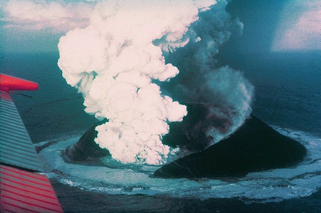
| İzah | Surtsey on November 30, 1963, 16 days after the beginning of the eruption. |
| Tarix | |
| Mənbə | http://www.ngdc.noaa.gov/seg/hazard/slideset/28/28_580_slide.shtml |
| Müəllif | Howell Williams, NOAA |
| Object location | | View this and other nearby images on: OpenStreetMap |
|---|
Lisenziya
This image is in the public domain because it contains materials that originally came from the U.S. National Oceanic and Atmospheric Administration, taken or made as part of an employee's official duties. |
Faylın tarixçəsi
Faylın əvvəlki versiyasını görmək üçün gün/tarix bölməsindəki tarixlərə klikləyin.
| Tarix/Vaxt | Miniatür | Ölçülər | İstifadəçi | Şərh | |
|---|---|---|---|---|---|
| hal-hazırkı | 09:29, 1 may 2006 | | 982 × 652 (146 KB) | Wirthi | Surtsey on November 30, 1963, 16 days after the begin of the eruption. Image: Howell Williams. Image source: [http://www.ngdc.noaa.gov/seg/hazard/slideset/28/28_580_slide.shtml NOAA]. {{PD-USGov-DOC-NOAA}} |
Faylın istifadəsi
Aşağıdakı 2 səhifə bu faylı istifadə edir:
Faylın qlobal istifadəsi
Bu fayl aşağıdakı vikilərdə istifadə olunur:
- ab.wikipedia.org layihəsində istifadəsi
- af.wikipedia.org layihəsində istifadəsi
- ar.wikipedia.org layihəsində istifadəsi
- bg.wikipedia.org layihəsində istifadəsi
- ceb.wikipedia.org layihəsində istifadəsi
- ce.wikipedia.org layihəsində istifadəsi
- cs.wikipedia.org layihəsində istifadəsi
- da.wikipedia.org layihəsində istifadəsi
- de.wikipedia.org layihəsində istifadəsi
- el.wikipedia.org layihəsində istifadəsi
- en.wikipedia.org layihəsində istifadəsi
- Surtsey
- Category talk:Geography
- November 1963
- Portal:Geography
- Portal:Geography/Featured article
- Portal:Iceland/Selected article
- Types of volcanic eruptions
- Portal:Iceland/Selected article/1
- Sigurður Þórarinsson
- Portal:Volcanoes/Selected article
- Wikipedia:Today's featured article/November 2008
- Wikipedia:Today's featured article/November 14, 2008
- Portal:Volcanoes/Selected article2
- Portal:Volcanoes/Selected article/15
- Portal:Geography/Featured article/14
- Portal:Islands/Selected article
- Portal:Europe/Featured location
- Portal:Europe/Featured location/5
- Portal:Islands/Selected article/71
- List of volcanic eruptions in Iceland
- eo.wikipedia.org layihəsində istifadəsi
- es.wikipedia.org layihəsində istifadəsi
- et.wikipedia.org layihəsində istifadəsi
- eu.wikipedia.org layihəsində istifadəsi
Bu faylın qlobal istifadəsinə baxın.
Metaməlumatlar
🔥 Top keywords: Natiq Qasımov (əsgər)Azərbaycan Respublikası Silahlı Qüvvələri GünüAna səhifəSəfərbərlik və Hərbi Xidmətə Çağırış üzrə Dövlət XidmətiAzərbaycan Silahlı QüvvələriAzərbaycan Daxili QoşunlarıUEFA Avro 2024Azərbaycan Sərhəd QoşunlarıƏləkbər Cahangirov777 saylı xüsusi təyinatlı əlahiddə hərbi hissəAzərbaycan Quru QoşunlarıXüsusi:AxtarAzərbaycanNamiq İslamzadəMüdafiə Nazirliyi (Azərbaycan)Dövlət Sərhəd Xidməti (Azərbaycan)Azərbaycanın Milli Qəhrəmanlarının siyahısıAzərbaycanın Milli QəhrəmanıQədir-XumVitali BalasanyanXüsusi Təyinatlı Qüvvələr (Azərbaycan)Xüsusi:SonDəyişikliklərKateqoriya:Qoşun növləriAzərbaycan Milli QvardiyasıKateqoriya:Hərbi rütbələrAzərbaycanın dövlət bayramları və xüsusi günləriFayl:Jön Türk Komitesi 1909.jpgİkinci Qarabağ müharibəsiHeydər ƏliyevKateqoriya:Kişi adlarıHikmət MirzəyevUEFA Avropa ÇempionatıHülakü xanAzərbaycan Hərbi Hava Qüvvələri"Qızıl Ulduz" medalı (Azərbaycan)Azərbaycan Xalq Cümhuriyyətinin Milli OrdusuKateqoriya:Əlifba sırasına görə futbolçularVisual Studio CodeQaşıq seks pozası