
Size of this preview: 800 × 192 pixels. Other resolutions: 320 × 77 pixels | 640 × 153 pixels | 1,024 × 245 pixels | 3,337 × 800 pixels.
Original file (3,337 × 800 pixels, file size: 907 KB, MIME type: image/jpeg)
| This is a file from the Wikimedia Commons. Information from its description page there is shown below. Commons is a freely licensed media file repository. You can help. |
Summary
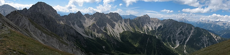
| Description | Deutsch: Westseite der Erlspitzgruppe (Karwendel) von N (Maderkarlspitze): Von links (O) nach rechts (W): Großer Solstein, Erlspitze, Kuhljochspitze, Freiungen, Reitherspitze, Seefelder Spitze, Seefelder Joch, Hohe Munde (Mieminger), Zugspitzplatt und Wettersteinhauptkamm |
| Date | |
| Source | photo taken by Kogo |
| Author | Kogo |
| Permission (Reusing this file) | GFDL |
| Camera location | | View this and other nearby images on: OpenStreetMap |
|---|
Licensing
I, the copyright holder of this work, hereby publish it under the following license:
 | Permission is granted to copy, distribute and/or modify this document under the terms of the GNU Free Documentation License, Version 1.2 or any later version published by the Free Software Foundation; with no Invariant Sections, no Front-Cover Texts, and no Back-Cover Texts. A copy of the license is included in the section entitled GNU Free Documentation License. |
| Annotations | This image is annotated: View the annotations at Commons |
File history
Click on a date/time to view the file as it appeared at that time.
| Date/Time | Thumbnail | Dimensions | User | Comment | |
|---|---|---|---|---|---|
| current | 21:56, 10 December 2007 | 3,337 × 800 (907 KB) | Kogo | {{Information |Description=Erlspitzgruppe (Karwendel) |Source=photo taken by Kogo |Date=26. August 2006 |Author=Kogo |Permission=GFDL |other_versions= }} |
File usage
The following pages on the English Wikipedia use this file (pages on other projects are not listed):
Global file usage
The following other wikis use this file:
- Usage on de.wikipedia.org
- Usage on es.wikipedia.org
- Usage on nl.wikipedia.org
Metadata
🔥 Top keywords: Akademia e Shkencave e RPS te ShqiperiseAlexandria Ocasio-CortezBilderberg GroupCristiano RonaldoDong XiaowanMinecraftOperation GladioPrimal cutRiot FestStrictly Come Dancing (series 7)Main PageSpecial:SearchKeir StarmerWikipedia:Featured picturesProject 2025UEFA Euro 20242024 United Kingdom general electionKalki 2898 ADKhyree JacksonMoney in the Bank (2024)Rishi SunakUEFA European Championship2024 Copa AméricaVictoria StarmerMasoud PezeshkianXherdan ShaqiriMichael Rubin (businessman)CleopatraA Quiet Place: Day One.xxxMurat YakinSrikanth BollaLove chairBukayo SakaAlexei PopyrinDeaths in 2024Cristiano RonaldoDespicable Me 4Inside Out 2Angela RaynerMaXXXineBreel EmboloMirzapur (TV series)Arda GülerBad Boys: Ride or DieCopa AméricaLabour Party (UK)Beverly Hills Cop: Axel FGareth Southgate