No higher resolution available.
FernSep61971.gif (450 × 497 pixels, file size: 199 KB, MIME type: image/gif)
| This is a file from the Wikimedia Commons. Information from its description page there is shown below. Commons is a freely licensed media file repository. You can help. |
Summary
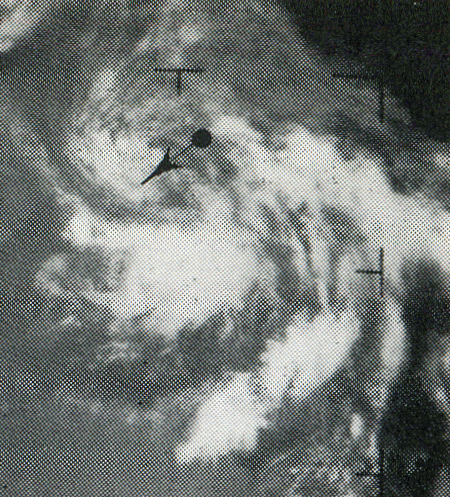
| Description | English: This weather satellite image of Tropical Depression Fern was taken on September 6, 1971 |
| Date | |
| Source | Mariners Weather Log, March 1973, pg. 84 |
| Author | NOAA |
| Camera location | | View this and other nearby images on: OpenStreetMap |
|---|
Licensing
This image is in the public domain because it contains materials that originally came from the U.S. National Oceanic and Atmospheric Administration, taken or made as part of an employee's official duties. |
File history
Click on a date/time to view the file as it appeared at that time.
| Date/Time | Thumbnail | Dimensions | User | Comment | |
|---|---|---|---|---|---|
| current | 16:07, 2 April 2013 | | 450 × 497 (199 KB) | Thegreatdr | User created page with UploadWizard |
File usage
The following pages on the English Wikipedia use this file (pages on other projects are not listed):
🔥 Top keywords: Akademia e Shkencave e RPS te ShqiperiseAlexandria Ocasio-CortezBilderberg GroupCristiano RonaldoDong XiaowanMinecraftOperation GladioPrimal cutRiot FestStrictly Come Dancing (series 7)Main PageSpecial:SearchUEFA Euro 2024Wikipedia:Featured picturesJulian AssangeShifty ShellshockFlorida PanthersList of Stanley Cup championsUEFA European ChampionshipPaul MauriceConnor McDavidMatthew TkachukCleopatraDeaths in 2024House of the Dragon2024 ICC Men's T20 World CupKeith Tkachuk2024 Copa AméricaCrazy TownStella AssangeChelsea ManningYouTubeElon MuskRoberto LuongoAnna Hall (athlete)ICC Men's T20 World CupMckenna GraceStanley CupJJ RedickConn Smythe Trophy.xxxInside Out 2Danny MakkelieZaheer IqbalAfghanistan national cricket teamMoney in the Bank (2024)Gordon Todd SkinnerProject 2025Dr Disrespect