Size of this preview: 800 × 337 pixels. Other resolutions: 320 × 135 pixels | 640 × 270 pixels | 1,500 × 632 pixels.
Original file (1,500 × 632 pixels, file size: 452 KB, MIME type: image/jpeg)
| This is a file from the Wikimedia Commons. Information from its description page there is shown below. Commons is a freely licensed media file repository. You can help. |
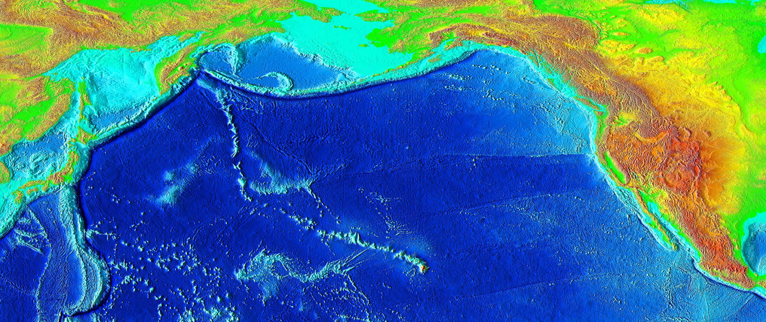
| Description | English: The trail of underwater mountains created as the tectonic plate moved across the Hawaii hotspot over millions of years, known as the Hawaiian-Emperor seamount chain, or the Emperor Seamounts. | |||
| Date | ||||
| Source | http://www.ngdc.noaa.gov/mgg/image/2minrelief.html | |||
| Author | National Geophysical Data Center/USGS | |||
| Permission (Reusing this file) |
|
| Annotations | This image is annotated: View the annotations at Commons |
File history
Click on a date/time to view the file as it appeared at that time.
| Date/Time | Thumbnail | Dimensions | User | Comment | |
|---|---|---|---|---|---|
| current | 04:42, 7 March 2006 | | 1,500 × 632 (452 KB) | Interiot~commonswiki | Higher resolution |
| 04:26, 7 March 2006 |  | 1,000 × 421 (201 KB) | Interiot~commonswiki | The trail of underwater mountains created as the the tectonic plate moved across the Hawaii hotspot over millions of years. Source: http://www.ngdc.noaa.gov/mgg/image/2minrelief.html |
File usage
The following pages on the English Wikipedia use this file (pages on other projects are not listed):
- Evolution of Hawaiian volcanoes
- Hawaii hotspot
- Hawaiian Islands
- Hawaiian–Emperor seamount chain
- Hotspot (geology)
- List of volcanoes in the Hawaiian–Emperor seamount chain
- Plate reconstruction
- Talk:Hawaiian Islands
- User talk:Resident Mario
- Wikipedia:Graphics Lab/Map workshop/Archive/Apr 2012
- Wikipedia:Main Page history/2022 October 21
- Wikipedia:Main Page history/2022 October 21b
- Wikipedia:Today's featured list/October 2022
- Wikipedia:Today's featured list/October 21, 2022
- Wikipedia:WikiProject Seamounts/Images
- Portal:Geography/Featured picture/2007, week 2
- Portal:Geography/Featured picture archive/2007
Global file usage
The following other wikis use this file:
- Usage on ba.wikipedia.org
- Usage on bg.wikipedia.org
- Usage on ca.wikipedia.org
- Usage on de.wikipedia.org
- Usage on en.wikibooks.org
- Usage on en.wikinews.org
- Usage on en.wikiquote.org
- Usage on en.wikisource.org
- Usage on en.wikiversity.org
- Usage on en.wikivoyage.org
- Usage on eo.wikipedia.org
- Usage on es.wikipedia.org
- Usage on eu.wikipedia.org
- Usage on fa.wikipedia.org
- Usage on foundation.wikimedia.org
- Usage on fr.wikipedia.org
- Usage on he.wikipedia.org
- Usage on hr.wikipedia.org
- Usage on it.wikipedia.org
- Usage on it.wikibooks.org
- Usage on it.wikiversity.org
- Usage on ja.wikipedia.org
- Usage on ja.wikibooks.org
- Usage on lt.wikipedia.org
- Usage on mk.wikipedia.org
- Usage on nl.wikipedia.org
- Usage on no.wikipedia.org
- Usage on pl.wikipedia.org
- Usage on ru.wikipedia.org
View more global usage of this file.
Metadata
🔥 Top keywords: Akademia e Shkencave e RPS te ShqiperiseAlexandria Ocasio-CortezBilderberg GroupCristiano RonaldoDong XiaowanMinecraftOperation GladioPrimal cutRiot FestStrictly Come Dancing (series 7)Main PageKeir Starmer2024 United Kingdom general electionSpecial:SearchRishi SunakWikipedia:Featured picturesVictoria StarmerProject 2025Labour Party (UK)2019 United Kingdom general electionKalki 2898 ADPrime Minister of the United KingdomUEFA Euro 2024List of recurring characters in the James Bond film seriesLiz TrussNigel FaragePepe (footballer, born 1983)Cristiano Ronaldo1997 United Kingdom general electionAngela RaynerRachel ReevesList of prime ministers of the United Kingdom2017 United Kingdom general electionUEFA European ChampionshipJeremy CorbynReform UKLamine YamalConservative Party (UK).xxxBoris JohnsonEmma RaducanuCleopatra2015 United Kingdom general electionFrances TiafoeKylian MbappéLiberal Democrats (UK)2024 Copa América2010 United Kingdom general electionJacob Rees-Mogg