List of ultras of North America
The following sortable tables comprise the most topographically prominent mountain peaks of greater North America. Each of these 353 summits has at least 1500 meters (4921 feet) of topographic prominence.

This article defines greater North America as the portion of the continental landmass of the Americas extending westward and northward from the Isthmus of Panama plus the islands surrounding that landmass. This article defines the islands of North America to include the coastal islands of North America, the islands of the Caribbean Sea, the Lucayan Archipelago, the Bermuda Islands, the Islands of Greenland (Kalaallit Nunaat), the islands of Northern Canada, the islands of Alaska, and the islands of the northeastern Pacific Ocean. The Hawaiian Islands are not included because they are considered part of Oceania.
Topographic elevation is the vertical distance above the reference geoid, a mathematical model of the Earth's sea level as an equipotential gravitational surface. The topographic prominence of a summit is the elevation difference between that summit and the highest or key col to a higher summit. The topographic isolation of a summit is the minimum great-circle distance to a point of equal elevation.
This article defines a significant summit as a summit with at least 100 meters (328.1 feet) of topographic prominence, and a major summit as a summit with at least 500 meters (1640 feet) of topographic prominence. An ultra-prominent summit is a summit with at least 1500 meters (4921 feet) of topographic prominence.
All elevations in the 48 states of the contiguous United States include an elevation adjustment from the National Geodetic Vertical Datum of 1929 (NGVD 29) to the North American Vertical Datum of 1988 (NAVD 88). For further information, please see this United States National Geodetic Survey note. If a summit elevation or prominence has a range of values, the arithmetic mean is cited.
Denali is one of only three summits on Earth (along with Mount Everest and Aconcagua) with more than 6000 meters (19,685 feet) of topographic prominence. Mount Logan exceeds 5000 meters (16,404 feet) of prominence. Four peaks of greater North America exceed 4000 meters (13,123 feet), ten exceed 3500 meters (11,483 feet), 17 exceed 3000 meters (9843 feet), 34 exceed 2500 meters (8202 feet) and 100 exceed 2000 meters (6562 feet) of topographic prominence.
Of these 353 ultra-prominent summits of North America, 143 are located in Canada, 122 in the United States, 38 in Greenland, 26 in México, eight in Honduras, six in Guatemala, four in El Salvador, three in Costa Rica, three in the Dominican Republic, two in Haiti, two in Nicaragua, and one each in Jamaica, Cuba, and Panamá. Six of these peaks lie on the Canada-United States border and one lies on the El Salvador-Honduras border.
Greenland
edit| Rank | Mountain Peak | Mountain Range | Elevation | Prominence | Isolation | Location |
|---|---|---|---|---|---|---|
| 1 | Gunnbjørn Fjeld[1][2][a] | Island of Greenland | 3694 m 12,119 ft | 3694 m 12,119 ft | 3,254.13 | 68.9184°N 29.8991°W |
| 2 | Stauning Alper[3] | Island of Greenland | 2831 m 9,288 ft | 2181 m 7,156 ft | 164.9 km 102.5 mi | 72.1167°N 24.9000°W |
| 3 | Palup Qaqa high point[4] | Upernivik Island | 2105 m 6,906 ft | 2105 m 6,906 ft | 31.2 km 19.4 mi | 71.3333°N 52.8167°W |
| 4 | Milne Land high point[5] | Island of Milne Land | 2050 m 6,726 ft | 2050 m 6,726 ft | 58.1 km 36.1 mi | 70.8194°N 26.5956°W |
| 5 | Payers Tinde[6] | Island of Greenland | 2320 m 7,612 ft | 2045 m 6,709 ft | 26.1 km 16.24 mi | 73.1333°N 26.3667°W |
| 6 | Perserajoq[7] | Island of Greenland | 2259 m 7,411 ft | 2009 m 6,591 ft | 527 km 328 mi | 71.4000°N 51.9667°W |
| 7 | Renland high point[8] | Island of Greenland | 2200 m 7,218 ft | 1950 m 6,398 ft | 100.8 km 62.6 mi | 71.3333°N 26.3333°W |
| 8 | Pyramiden[9][b] | Disko Island | 1904 m 6,247 ft | 1904 m 6,247 ft | 32.7 km 20.3 mi | 70.1195°N 53.3890°W |
| 9 | Angelin Bjerg[10][c] | Ymer Island | 1900 m 6,234 ft | 1900 m 6,234 ft | 43.7 km 27.1 mi | 73.1667°N 24.3167°W |
| 10 | Traill Island high point[11] | Traill Island | 1884 m 6,181 ft | 1884 m 6,181 ft | 50.8 km 31.6 mi | 72.7167°N 24.0667°W |
| 11 | Parnaqussuit Qavaat high point[12] | Island of Greenland | 1860 m 6,102 ft | 1820 m 5,971 ft | 36.9 km 23 mi | 66.4333°N 52.9167°W |
| 12 | Storo high point[13] | Island of Storo | 1770 m 5,807 ft | 1770 m 5,807 ft | 32.6 km 20.3 mi | 70.8333°N 27.4833°W| |
| 13 | Snehaetten[14][d] | Qeqertaq Island | 1765 m 5,791 ft | 1765 m 5,791 ft | 34.4 km 21.4 mi | 71.6542°N 53.1641°W |
| 14 | Azimuthbjerg[15][e] | Island of Skjoldungen | 1738 m 5,702 ft | 1738 m 5,702 ft | 140.5 km 87.3 mi | 63.4552°N 41.8508°W |
| 15 | Svedenborg Bjerg[16][f] | Geographical Society Island | 1730 m 5,676 ft | 1730 m 5,676 ft | 24.9 km 15.48 mi | 72.9436°N 24.3412°W |
| 16 | Appaalik[17][g] | Appat Island | 1711 m 5,614 ft | 1711 m 5,614 ft | 45.6 km 28.3 mi | 70.9474°N 51.9918°W |
| 17 | Hahn Land high point[18][h] | Island of Greenland | 1744 m 5,722 ft | 1694 m 5,558 ft | 347 km 216 mi | 80.4333°N 19.8333°W |
| 18 | Nuussuaq high point[19][i] | Island of Greenland | 2144 m 7,034 ft | 1669 m 5,476 ft | 86.6 km 53.8 mi | 70.6966°N 52.9728°W |
| 19 | Hardersbjerg[20] | Island of Greenland | 1679 m 5,509 ft | 1658 m 5,440 ft | 56.2 km 34.9 mi | 73.4333°N 22.8333°W |
| 20 | Klosterbjerge[21] | Island of Greenland | 2410 m 7,907 ft | 1635 m 5,364 ft | 38.8 km 24.1 mi | 72.2500°N 25.9500°W |
| 21 | Qingagssat Qaqit[22] | Island of Greenland | 1782 m 5,846 ft | 1632 m 5,354 ft | 23.3 km 14.47 mi | 60.5654°N 44.6949°W |
| 22 | Ejnar Mikkelsen Fjeld[23] | Island of Greenland | 3325 m 10,909 ft | 1625 m 5,331 ft | 16.29 km 10.12 mi | 68.8957°N 28.6279°W |
| 23 | Agssaussat[24] | Island of Greenland | 2140 m 7,021 ft | 1615 m 5,299 ft | 18.06 km 11.22 mi | 65.8833°N 52.1167°W |
| 24 | Kloftbjerge[25] | Island of Greenland | 2163 m 7,096 ft | 1613 m 5,292 ft | 92.3 km 57.4 mi | 71.3333°N 25.7500°W |
| 25 | Salliaruseq high point[26] | Salliaruseq Island | 1610 m 5,282 ft | 1610 m 5,282 ft | 29.5 km 18.32 mi | 64.3913°N 51.1134°W |
| 26 | Clavering Island high point[27] | Clavering Island | 1604 m 5,262 ft | 1604 m 5,262 ft | 77.1 km 47.9 mi | 74.3667°N 21.1833°W |
| 27 | Schweizerland high point[28] | Island of Greenland | 1671 m 5,482 ft | 1596 m 5,236 ft | 95.4 km 59.3 mi | 66.1203°N 37.4420°W |
| 28 | Margaretatopp[29] | Island of Greenland | 2360 m 7,743 ft | 1585 m 5,200 ft | 69 km 42.9 mi | 73.3667°N 26.3000°W |
| Paatuut[30] | Island of Greenland | 2010 m 6,594 ft | 1585 m 5,200 ft | 45.8 km 28.4 mi | 70.2966°N 52.7017°W | |
| Agdleruussakasit[31] | Island of Greenland | 1763 m 5,784 ft | 1585 m 5,200 ft | 5.75 km 3.57 mi | 60.1364°N 44.5293°W | |
| 31 | Mont Forel[32] | Schweizerland | 3391 m 11,125 ft | 1581 m 5,187 ft | 357 km 222 mi | 66.9354°N 36.7873°W |
| 32 | Blaskbjerg[33] | Island of Greenland | 1600 m 5,249 ft | 1575 m 5,167 ft | 17.46 km 10.85 mi | 73.3000°N 24.0333°W |
| 33 | Kinaussak[34] | Island of Greenland | 1630 m 5,348 ft | 1555 m 5,102 ft | 88.3 km 54.9 mi | 64.4500°N 50.5167°W |
| 34 | Gaaseland high point[35] | Island of Greenland | 2100 m 6,890 ft | 1550 m 5,085 ft | 135.6 km 84.3 mi | 70.2000°N 27.6667°W |
| 35 | Sangmissoq high point[36] | Island of Sammisoq | 1549 m 5,082 ft | 1549 m 5,082 ft | 35.5 km 22.1 mi | 60.0502°N 43.9164°W |
| 36 | Favres Bjerg[37] | Island of Greenland | 2000 m 6,562 ft | 1546 m 5,072 ft | 117.1 km 72.8 mi | 73.9500°N 23.2000°W |
| 37 | Johnstrup Bjerge[38] | Island of Greenland | 2000 m 6,562 ft | 1540 m 5,052 ft | 30.9 km 19.21 mi | 73.0000°N 25.5333°W |
| 38 | Berzelius Bjerg[39] | Island of Greenland | 1810 m 5,938 ft | 1535 m 5,036 ft | 38.5 km 23.9 mi | 72.4667°N 25.0667°W |
Canadian Arctic Archipelago
edit| Rank | Mountain Peak | Mountain Range | Elevation | Prominence | Isolation | Location |
|---|---|---|---|---|---|---|
| 1 | Barbeau Peak | Ellesmere Island | 2616 m 8,583 ft | 2616 m 8,583 ft | 796 km 495 mi | 81.9138°N 75.0116°W |
| 2 | Outlook Peak | Axel Heiberg Island | 2210 m 7,251 ft | 2210 m 7,251 ft | 268 km 166.3 mi | 79.7397°N 91.4061°W |
| 3 | Mount Odin | Baffin Island | 2143 m 7,031 ft | 2143 m 7,031 ft | 586 km 364 mi | 66.5468°N 65.4289°W |
| 4 | South Ellesmere Ice Cap High Point | Ellesmere Island | 2347 m 7,700 ft | 2044 m 6,706 ft | 350 km 217 mi | 78.8007°N 79.5292°W |
| 5 | Angilaaq Mountain | Bylot Island | 1944 m 6,378 ft | 1944 m 6,378 ft | 147.6 km 91.7 mi | 73.2298°N 78.6230°W |
| 6 | Devon Ice Cap High Point | Devon Island | 1920 m 6,300 ft | 1920 m 6,300 ft | 265 km 164.6 mi | 75.3429°N 82.6186°W |
| 7 | Qiajivik Mountain | Baffin Island | 1963 m 6,440 ft | 1787 m 5,863 ft | 725 km 450 mi | 72.1806°N 75.9111°W |
| 8 | Peak 08-46 | Ellesmere Island | 2181 m 7,156 ft | 1745 m 5,725 ft | 35.1 km 21.8 mi | 80.1370°N 76.7763°W |
| 9 | Ukpik Peak | Baffin Island | 1809 m 5,935 ft | 1650 m 5,413 ft | 16.35 km 10.16 mi | 70.6942°N 71.3417°W |
| 10 | Tupeq Mountain | Baffin Island | 2020 m 6,627 ft | 1638 m 5,374 ft | 14.21 km 8.83 mi | 66.5737°N 65.0717°W |
| 11 | Peak 1840 | Baffin Island | 1840 m 6,037 ft | 1617 m 5,305 ft | 84.9 km 52.8 mi | 66.1519°N 63.4918°W |
| 12 | Kisimngiuqtuq Peak | Baffin Island | 1905 m 6,250 ft | 1605 m 5,266 ft | 216 km 134.1 mi | 70.7972°N 71.6500°W |
| 13 | Sillem Island High Point | Sillem Island | 1590 m 5,217 ft | 1590 m 5,217 ft | 23.9 km 14.86 mi | 71.0017°N 71.8550°W |
| 14 | Peak 39-18 | Baffin Island | 1721 m 5,646 ft | 1564 m 5,131 ft | 139 km 86.4 mi | 69.6500°N 69.3000°W |
| 15 | Peak 35-44 | Baffin Island | 1562 m 5,125 ft | 1559 m 5,115 ft | 10.81 km 6.72 mi | 70.5800°N 70.7283°W |
| 16 | Angna Mountain | Baffin Island | 1710 m 5,610 ft | 1510 m 4,954 ft | 73.7 km 45.8 mi | 66.5595°N 62.0273°W |
Brooks Range
edit| Rank | Mountain Peak | Mountain Range | Elevation | Prominence | Isolation | Location |
|---|---|---|---|---|---|---|
| 1 | Mount Isto | Brooks Range | 2736 m 8,976 ft | 2401 m 7,877 ft | 635 km 395 mi | 69.2020°N 143.80196°W |
| 2 | Mount Igikpak | Brooks Range | 2523 m 8,276 ft | 1867 m 6,126 ft | 453 km 282 mi | 67.4129°N 154.9656°W |
Aleutian Islands
edit| Rank | Mountain Peak | Mountain Range | Elevation | Prominence | Isolation | Location |
|---|---|---|---|---|---|---|
| 1 | Shishaldin Volcano | Unimak Island | 2869 m 9,414 ft | 2869 m 9,414 ft | 877 km 545 mi | 54.7554°N 163.9709°W |
| 2 | Mount Vsevidof | Umnak Island | 2149 m 7,051 ft | 2149 m 7,051 ft | 359 km 223 mi | 53.1251°N 168.6947°W |
| 3 | Pogromni Volcano | Unimak Island | 1991 m 6,531 ft | 1884 m 6,181 ft | 50.9 km 31.7 mi | 54.5705°N 164.6926°W |
| 4 | Tanaga Volcano | Tanaga Island | 1806 m 5,925 ft | 1806 m 5,925 ft | 656 km 407 mi | 51.8833°N 178.1333°W |
| 5 | Makushin Volcano | Unalaska Island | 1800 m 5,905 ft | 1800 m 5,905 ft | 133.9 km 83.2 mi | 53.8782°N 166.9299°W |
| 6 | Isanotski Peaks | Unimak Island | 2471 m 8,106 ft | 1785 m 5,856 ft | 15.62 km 9.71 mi | 54.7515°N 163.7288°W |
| 7 | Great Sitkin Volcano | Great Sitkin Island | 1740 m 5,710 ft | 1740 m 5,710 ft | 139.9 km 86.9 mi | 52.0756°N 176.1114°W |
| 8 | Mount Cleveland | Chuginadak Island | 1730 m 5,675 ft | 1730 m 5,675 ft | 90.7 km 56.3 mi | 52.8230°N 169.9465°W |
| 9 | Carlisle Volcano | Carlisle Island | 1610 m 5,283 ft | 1610 m 5,283 ft | 10.53 km 6.54 mi | 52.8913°N 170.0580°W |
| 10 | Mount Gareloi | Gareloi Island | 1573 m 5,160 ft | 1573 m 5,160 ft | 46.3 km 28.7 mi | 51.7880°N 178.7940°W |
| 11 | Korovin Volcano | Atka Island | 1533 m 5,030 ft | 1533 m 5,030 ft | 138.3 km 85.9 mi | 52.3789°N 174.1561°W |
Aleutian Range
edit| Rank | Mountain Peak | Mountain Range | Elevation | Prominence | Isolation | Location |
|---|---|---|---|---|---|---|
| 1 | Redoubt Volcano | Aleutian Range | 3108 m 10,197 ft | 2788 m 9,147 ft | 94.5 km 58.7 mi | 60.4851°N 152.7439°W |
| 2 | Pavlof Volcano | Aleutian Range | 2515 m 8,250 ft | 2507 m 8,225 ft | 151.8 km 94.3 mi | 55.4175°N 161.8932°W |
| 3 | Mount Veniaminof | Aleutian Range | 2507 m 8,225 ft | 2499 m 8,200 ft | 337 km 210 mi | 56.2191°N 159.2980°W |
| 4 | Iliamna Volcano | Aleutian Range | 3053 m 10,016 ft | 2398 m 7,866 ft | 54.1 km 33.6 mi | 60.0321°N 153.0915°W |
| 5 | Mount Griggs | Aleutian Range | 2332 m 7,650 ft | 2225 m 7,300 ft | 219 km 136.3 mi | 58.3534°N 155.0958°W |
| 6 | Mount Chiginagak | Aleutian Range | 2111 m 6,925 ft | 2035 m 6,675 ft | 157.2 km 97.7 mi | 57.1312°N 156.9836°W |
| 7 | Mount Neacola | Aleutian Range | 2873 m 9,426 ft | 1943 m 6,376 ft | 49.9 km 31 mi | 60.7981°N 153.3959°W |
| 8 | Mount Douglas | Aleutian Range | 2149 m 7,050 ft | 1920 m 6,300 ft | 69 km 42.9 mi | 58.8598°N 153.5353°W |
| 9 | Frosty Peak | Aleutian Range | 1769 m 5,803 ft | 1754 m 5,753 ft | 56.9 km 35.4 mi | 55.0672°N 162.8349°W |
Alaska Range
edit| Rank | Mountain Peak | Mountain Range | Elevation | Prominence | Isolation | Location |
|---|---|---|---|---|---|---|
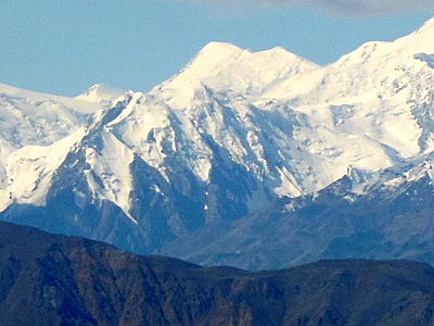
| 1 | Denali[40] | Alaska Range | 6191 m 20,310 ft | 6141 m 20,146 ft | 7,450 km 4,629 mi | 63.0690°N 151.0063°W |
| 2 | Mount Hayes | Alaska Range | 4216 m 13,832 ft | 3507 m 11,507 ft | 205 km 127.2 mi | 63.6199°N 146.7174°W |
| 3 | Mount Torbert | Alaska Range | 3479 m 11,413 ft | 2648 m 8,688 ft | 157.3 km 97.8 mi | 61.4086°N 152.4125°W |
| 4 | Mount Kimball | Alaska Range | 3155 m 10,350 ft | 2263 m 7,425 ft | 89.8 km 55.8 mi | 63.2390°N 144.6419°W |
| 5 | Mount Foraker | Alaska Range | 5304 m 17,400 ft | 2210 m 7,250 ft | 23 km 14.27 mi | 62.9605°N 151.3992°W |
| 6 | Mount Hesperus | Alaska Range | 2996 m 9,828 ft | 2127 m 6,978 ft | 93.5 km 58.1 mi | 61.8036°N 154.1469°W |
| 7 | Kichatna Spire | Alaska Range | 2739 m 8,985 ft | 1900 m 6,235 ft | 60 km 37.3 mi | 62.4231°N 152.7231°W |
| 8 | Mount Russell | Alaska Range | 3557 m 11,670 ft | 1682 m 5,520 ft | 24.2 km 15.04 mi | 62.7983°N 151.8844°W |
| 9 | Tetlin Peak | Alaska Range | 2550 m 8,365 ft | 1597 m 5,240 ft | 41.1 km 25.5 mi | 62.6215°N 143.1084°W |
| 10 | Mount Deborah | Alaska Range | 3761 m 12,339 ft | 1582 m 5,189 ft | 25.9 km 16.08 mi | 63.6379°N 147.2382°W |
| 11 | Necous Peak | Alaska Range | 2541 m 8,336 ft | 1581 m 5,186 ft | 35.3 km 21.9 mi | 61.1125°N 153.4690°W |
| 12 | Stony Peak | Alaska Range | 2587 m 8,488 ft | 1566 m 5,138 ft | 19.19 km 11.92 mi | 61.4950°N 153.6224°W |
Wrangell Mountains
edit| Rank | Mountain Peak | Mountain Range | Elevation | Prominence | Isolation | Location |
|---|---|---|---|---|---|---|
| 1 | Mount Blackburn | Wrangell Mountains | 4996 m 16,390 ft | 3548 m 11,640 ft | 97.6 km 60.7 mi | 61.7305°N 143.4031°W |
| 2 | Mount Sanford | Wrangell Mountains | 4949 m 16,237 ft | 2343 m 7,687 ft | 64.8 km 40.3 mi | 62.2132°N 144.1292°W |
| 3 | Mount Drum | Wrangell Mountains | 3661 m 12,010 ft | 2060 m 6,760 ft | 28.5 km 17.73 mi | 62.1159°N 144.6394°W |
| 4 | Mount Wrangell | Wrangell Mountains | 4317 m 14,163 ft | 1711 m 5,613 ft | 23.8 km 14.79 mi | 62.0059°N 144.0187°W |
Talkeetna Mountains
edit| Rank | Mountain Peak | Mountain Range | Elevation | Prominence | Isolation | Location |
|---|---|---|---|---|---|---|
| 1 | Sovereign Mountain | Talkeetna Mountains | 2697 m 8,849 ft | 1790 m 5,874 ft | 76.6 km 47.6 mi | 62.1311°N 148.6044°W |
Kenai Mountains
edit| Rank | Mountain Peak | Mountain Range | Elevation | Prominence | Isolation | Location |
|---|---|---|---|---|---|---|
| 1 | Truuli Peak | Kenai Mountains | 2015 m 6,612 ft | 1848 m 6,062 ft | 143.1 km 88.9 mi | 59.9129°N 150.4348°W |
| 2 | Isthmus Peak | Kenai Mountains | 1991 m 6,532 ft | 1762 m 5,782 ft | 52 km 32.3 mi | 60.5772°N 148.8908°W |
Chugach Mountains
edit| Rank | Mountain Peak | Mountain Range | Elevation | Prominence | Isolation | Location |
|---|---|---|---|---|---|---|
| 1 | Mount Marcus Baker | Chugach Mountains | 4016 m 13,176 ft | 3277 m 10,751 ft | 204 km 126.8 mi | 61.4374°N 147.7525°W |
| 2 | Mount Tom White | Chugach Mountains | 3411 m 11,191 ft | 2329 m 7,641 ft | 117.6 km 73 mi | 60.6512°N 143.6970°W |
| 3 | De Long Peak | Chugach Mountains | 2464 m 8,084 ft | 1900 m 6,234 ft | 80.8 km 50.2 mi | 60.8299°N 145.1335°W |
| 4 | Dewey Peak(Alaska) | Chugach Mountains | 2441 m 8,010 ft | 1878 m 6,160 ft | 40.7 km 25.3 mi | 61.1605°N 144.8129°W |
| 5 | Hanagita Peak | Chugach Mountains | 2592 m 8,504 ft | 1815 m 5,954 ft | 45.1 km 28 mi | 61.0670°N 143.7075°W |
| 6 | Mount Steller | Chugach Mountains | 3216 m 10,550 ft | 1635 m 5,365 ft | 36.2 km 22.5 mi | 58.4299°N 154.3893°W |
| 7 | Bashful Peak | Chugach Mountains | 2440 m 8,005 ft | 1608 m 5,275 ft | 36.8 km 22.9 mi | 61.3076°N 148.8697°W |
| 8 | Copper Peak | Chugach Mountains | 2108 m 6,915 ft | 1544 m 5,065 ft | 17.87 km 11.1 mi | 61.3297°N 144.9599°W |
Saint Elias Mountains
edit| Rank | Mountain Peak | Region | Mountain Range | Elevation | Prominence | Isolation | Location |
|---|---|---|---|---|---|---|---|
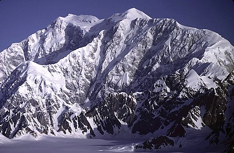
| 1 | Mount Logan |  Yukon Yukon | Saint Elias Mountains | 5959 m 19,551 ft | 5247 m 17,215 ft | 623 km 387 mi | 60.5666°N 140.4072°W |
| 2 | Mount Fairweather (Fairweather Mountain) |  British Columbia British Columbia | Saint Elias Mountains | 4671 m 15,325 ft | 3961 m 12,995 ft | 201 km 124.7 mi | 58.9064°N 137.5265°W |
| 3 | Mount Saint Elias | Yukon | Saint Elias Mountains | 5489 m 18,008 ft | 3429 m 11,250 ft | 41.2 km 25.6 mi | 60.2927°N 140.9307°W |
| 4 | Mount Lucania | Yukon | Saint Elias Mountains | 5260 m 17,257 ft | 3080 m 10,105 ft | 43 km 26.7 mi | 61.0215°N 140.4661°W |
| 5 | Mount Vancouver | Yukon | Saint Elias Mountains | 4812 m 15,787 ft | 2712 m 8,898 ft | 44.1 km 27.4 mi | 60.3589°N 139.6980°W |
| 6 | Mount Hubbard | Yukon | Saint Elias Mountains | 4557 m 14,950 ft | 2457 m 8,061 ft | 34.4 km 21.3 mi | 60.3194°N 139.0726°W |
| 7 | Mount Cook | Yukon | Saint Elias Mountains | 4194 m 13,760 ft | 2350 m 7,710 ft | 23.4 km 14.54 mi | 60.1816°N 139.9811°W |
| 8 | Mount Crillon | Saint Elias Mountains | 3879 m 12,726 ft | 2187 m 7,176 ft | 31.4 km 19.52 mi | 58.6625°N 137.1716°W | |
| 9 | Mount Bona | Saint Elias Mountains | 5044 m 16,550 ft | 2103 m 6,900 ft | 80 km 49.7 mi | 61.3845°N 141.7529°W | |
| 10 | Alsek Peak | Yukon | Saint Elias Mountains | 2720 m 8,924 ft | 2025 m 6,644 ft | 68.5 km 42.5 mi | 60.0325°N 137.5915°W |
| 11 | Mount Cairnes | Yukon | Saint Elias Mountains | 2820 m 9,252 ft | 2000 m 6,562 ft | 40.2 km 25 mi | 60.8683°N 138.2764°W |
| 12 | Buckwell Peak | British Columbia Yukon | Saint Elias Mountains | 2721 m 8,927 ft | 1971 m 6,467 ft | 56.4 km 35 mi | 59.4188°N 136.7653°W |
| 13 | Detour Peak | British Columbia Yukon | Saint Elias Mountains | 2550 m 8,366 ft | 1906 m 6,253 ft | 21.2 km 13.16 mi | 59.8424°N 137.5856°W |
| 14 | Mount Natazhat | Saint Elias Mountains | 4095 m 13,435 ft | 1824 m 5,985 ft | 24.9 km 15.49 mi | 61.5217°N 141.1030°W | |
| 15 | Mount Martha Black | Yukon | Saint Elias Mountains | 2512 m 8,241 ft | 1797 m 5,896 ft | 18.59 km 11.55 mi | 60.6716°N 137.6224°W |
| 16 | Mount Seattle | Saint Elias Mountains | 3155 m 10,350 ft | 1695 m 5,561 ft | 19.26 km 11.97 mi | 60.0664°N 139.1908°W | |
| 17 | Mount Archibald | Yukon | Saint Elias Mountains | 2588 m 8,491 ft | 1678 m 5,505 ft | 23.8 km 14.81 mi | 60.7842°N 137.8736°W |
| 18 | Mount Foresta | Saint Elias Mountains | 3368 m 11,050 ft | 1646 m 5,400 ft | 20.1 km 12.51 mi | 60.1912°N 139.4323°W | |
| 19 | Bearhole Peak | Saint Elias Mountains | 2596 m 8,517 ft | 1636 m 5,367 ft | 43.5 km 27 mi | 60.9283°N 142.5237°W | |
| 20 | Mount Miller | Saint Elias Mountains | 3277 m 10,750 ft | 1615 m 5,300 ft | 64.9 km 40.3 mi | 60.4605°N 142.3012°W | |
| 21 | Mount Augusta | Yukon | Saint Elias Mountains | 4289 m 14,070 ft | 1549 m 5,082 ft | 23.2 km 14.41 mi | 60.3074°N 140.4584°W |
| 22 | Dalton Peak | Yukon | Saint Elias Mountains | 2329 m 7,641 ft | 1549 m 5,082 ft | 32.9 km 20.4 mi | 60.4767°N 137.1728°W |
| 23 | Mount Bear | Saint Elias Mountains | 4520 m 14,831 ft | 1540 m 5,052 ft | 32.4 km 20.1 mi | 61.2834°N 141.1433°W |
Mackenzie Mountains and the Yukon Plateau
edit| Rank | Mountain Peak | Region | Mountain Range | Elevation | Prominence | Isolation | Location |
|---|---|---|---|---|---|---|---|
| 1 | Keele Peak | Yukon | Mackenzie Mountains | 2952 m 9,685 ft | 2161 m 7,090 ft | 543 km 337 mi | 63.4314°N 130.3243°W |
| 2 | Mount Nirvana |  Northwest Territories Northwest Territories | Mackenzie Mountains | 2773 m 9,098 ft | 1663 m 5,456 ft | 220 km 136.8 mi | 61.8752°N 127.6807°W |
| 3 | Mount Macdonald | Yukon | Mackenzie Mountains | 2760 m 9,055 ft | 1555 m 5,102 ft | 187.5 km 116.5 mi | 64.7256°N 132.7781°W |
| 4 | Pass Mountain | Yukon | Mackenzie Mountains | 2515 m 8,250 ft | 1524 m 5,000 ft | 29.2 km 18.11 mi | 64.5140°N 133.6254°W |
| 5 | Grey Hunter Peak | Yukon | North Yukon Plateau | 2214 m 7,264 ft | 1519 m 4,984 ft | 178.7 km 111 mi | 63.1357°N 135.6359°W |
Alexander Archipelago and Vancouver Island
edit| Rank | Mountain Peak | Region | Mountain Range | Elevation | Prominence | Isolation | Location |
|---|---|---|---|---|---|---|---|
| 1 | Golden Hinde | British Columbia | Vancouver Island | 2195 m 7,201 ft | 2195 m 7,201 ft | 154.8 km 96.2 mi | 49.6627°N 125.7470°W |
| 2 | Victoria Peak | British Columbia | Vancouver Island | 2159 m 7,083 ft | 1845 m 6,053 ft | 35.4 km 22 mi | 50.0547°N 126.1008°W |
| 3 | Baranof Island High Point | Baranof Island | 1643 m 5,390 ft | 1643 m 5,390 ft | 128.3 km 79.7 mi | 57.0151°N 134.9882°W | |
| 4 | Rugged Mountain | British Columbia | Vancouver Island | 1861 m 6,106 ft | 1571 m 5,154 ft | 41.5 km 25.8 mi | 50.0252°N 126.6778°W |
| 5 | Hkusam Mountain | British Columbia | Vancouver Island | 1645 m 5,397 ft | 1508 m 4,948 ft | 36.3 km 22.5 mi | 50.3349°N 125.8407°W |
Coast Mountains
edit| Rank | Mountain Peak | Region | Mountain Range | Elevation | Prominence | Isolation | Location |
|---|---|---|---|---|---|---|---|
| 1 | Mount Waddington | British Columbia | Coast Mountains | 4019 m 13,186 ft | 3289 m 10,791 ft | 562 km 349 mi | 51.3737°N 125.2636°W |
| 2 | Monarch Mountain | British Columbia | Coast Mountains | 3555 m 11,663 ft | 2925 m 9,596 ft | 71.4 km 44.4 mi | 51.8995°N 125.8760°W |
| 3 | Skihist Mountain | British Columbia | Coast Mountains | 2968 m 9,738 ft | 2458 m 8,064 ft | 157.1 km 97.6 mi | 50.1878°N 121.9032°W |
| 4 | Mount Ratz | British Columbia | Coast Mountains | 3090 m 10,138 ft | 2430 m 7,972 ft | 311 km 193.4 mi | 57.3930°N 132.3031°W |
| 5 | Mount Queen Bess | British Columbia | Coast Mountains | 3298 m 10,820 ft | 2355 m 7,726 ft | 45.5 km 28.3 mi | 51.2714°N 124.5682°W |
| 6 | Wedge Mountain | British Columbia | Coast Mountains | 2892 m 9,488 ft | 2249 m 7,379 ft | 63.9 km 39.7 mi | 50.1330°N 122.7933°W |
| 7 | Otter Mountain | British Columbia | Coast Mountains | 2692 m 8,832 ft | 2242 m 7,356 ft | 25.4 km 15.78 mi | 56.0066°N 129.6928°W |
| 8 | Kwatna Peak | British Columbia | Coast Mountains | 2290 m 7,513 ft | 2225 m 7,300 ft | 36.9 km 22.9 mi | 52.0706°N 126.9630°W |
| 9 | Scud Peak | British Columbia | Coast Mountains | 2987 m 9,800 ft | 2172 m 7,126 ft | 57.4 km 35.7 mi | 57.2412°N 131.1676°W |
| 10 | Razorback Mountain | British Columbia | Coast Mountains | 3183 m 10,443 ft | 2153 m 7,064 ft | 36.5 km 22.7 mi | 51.5905°N 124.6912°W |
| 11 | Oscar Peak | British Columbia | Coast Mountains | 2336 m 7,664 ft | 2099 m 6,886 ft | 35.5 km 22 mi | 54.9289°N 129.0594°W |
| 12 | Mount Jancowski | British Columbia | Coast Mountains | 2729 m 8,953 ft | 2079 m 6,821 ft | 124 km 77.1 mi | 56.3372°N 129.9817°W |
| 13 | Mount Valpy | British Columbia | Coast Mountains | 2219 m 7,280 ft | 2014 m 6,608 ft | 49.4 km 30.7 mi | 54.2750°N 129.0564°W |
| 14 | Chatsquot Mountain | British Columbia | Coast Mountains | 2365 m 7,759 ft | 1981 m 6,499 ft | 57.7 km 35.8 mi | 53.1422°N 127.4773°W |
| 15 | Mount Priestley | British Columbia | Coast Mountains | 2366 m 7,762 ft | 1945 m 6,381 ft | 50.4 km 31.3 mi | 55.2297°N 128.8759°W |
| 16 | Sharks Teeth Peaks | British Columbia | Coast Mountains | 2304 m 7,559 ft | 1914 m 6,280 ft | 21.9 km 13.6 mi | 53.0071°N 127.2400°W |
| 17 | Snow Tower | Coast Mountains | 2003 m 6,572 ft | 1866 m 6,122 ft | 24.3 km 15.07 mi | 58.1724°N 133.4009°W | |
| 18 | Seven Sisters Peaks | British Columbia | Coast Mountains | 2747 m 9,012 ft | 1862 m 6,109 ft | 68.8 km 42.7 mi | 54.9678°N 128.2319°W |
| 19 | Mount Saugstad | British Columbia | Coast Mountains | 2908 m 9,541 ft | 1850 m 6,070 ft | 38.6 km 24 mi | 52.2542°N 126.5148°W |
| 20 | Brian Boru Peak | British Columbia | Coast Mountains | 2507 m 8,225 ft | 1832 m 6,010 ft | 32.8 km 20.4 mi | 55.0739°N 127.5742°W |
| 21 | Howson Peak | British Columbia | Coast Mountains | 2759 m 9,052 ft | 1829 m 6,001 ft | 254 km 158 mi | 54.4185°N 127.7441°W |
| 22 | Atna Peak | British Columbia | Coast Mountains | 2724 m 8,937 ft | 1828 m 5,997 ft | 56.8 km 35.3 mi | 53.9398°N 128.0456°W |
| 23 | Tsaydaychuz Peak | British Columbia | Coast Mountains | 2758 m 9,049 ft | 1826 m 5,991 ft | 82.8 km 51.4 mi | 53.0212°N 126.6401°W |
| 24 | Birkenhead Peak | British Columbia | Coast Mountains | 2506 m 8,222 ft | 1781 m 5,843 ft | 21 km 13.06 mi | 50.5112°N 122.6210°W |
| 25 | Chutine Peak | British Columbia | Coast Mountains | 2903 m 9,524 ft | 1758 m 5,768 ft | 42.6 km 26.5 mi | 57.7753°N 132.3346°W |
| 26 | Unuk Peak | British Columbia | Coast Mountains | 2595 m 8,514 ft | 1725 m 5,659 ft | 13.79 km 8.57 mi | 56.3764°N 130.1933°W |
| 27 | Devils Paw | British Columbia | Coast Mountains | 2593 m 8,507 ft | 1720 m 5,643 ft | 138.3 km 85.9 mi | 58.7296°N 133.8407°W |
| 28 | Sittakanay Peak | British Columbia | Coast Mountains | 2415 m 7,923 ft | 1710 m 5,610 ft | 39.4 km 24.5 mi | 58.4786°N 133.3623°W |
| 29 | Thunder Mountain | British Columbia | Coast Mountains | 2664 m 8,740 ft | 1694 m 5,558 ft | 27.6 km 17.14 mi | 52.5531°N 126.3698°W |
| 30 | Overseer Mountain | British Columbia | Coast Mountains | 2749 m 9,019 ft | 1679 m 5,509 ft | 19.39 km 12.05 mi | 50.5288°N 123.3809°W |
| 31 | King Island High Point | British Columbia | King Island | 1679 m 5,509 ft | 1679 m 5,509 ft | 36.5 km 22.7 mi | 52.3216°N 127.3065°W |
| 32 | Talchako Mountain | British Columbia | Coast Mountains | 3037 m 9,964 ft | 1676 m 5,499 ft | 23.5 km 14.58 mi | 52.0919°N 126.0159°W |
| 33 | Whiting Peak | British Columbia | Coast Mountains | 2524 m 8,281 ft | 1669 m 5,476 ft | 53.9 km 33.5 mi | 58.1389°N 132.9346°W |
| 34 | Faisal Peak | British Columbia | Coast Mountains | 2239 m 7,346 ft | 1669 m 5,476 ft | 34 km 21.1 mi | 56.8857°N 130.5798°W |
| 35 | Mount Lester Jones | British Columbia | Coast Mountains | 2408 m 7,900 ft | 1658 m 5,440 ft | 27.7 km 17.21 mi | 58.7174°N 133.2306°W |
| 36 | Hubris Peak | British Columbia | Coast Mountains | 2445 m 8,022 ft | 1640 m 5,381 ft | 51.9 km 32.2 mi | 56.5518°N 130.9733°W |
| 37 | Mount Porsild | Yukon | Coast Mountains | 2540 m 8,333 ft | 1630 m 5,348 ft | NA | 60.0839°N 136.0153°W |
| 38 | Mount Judge Howay | British Columbia | Coast Mountains | 2262 m 7,421 ft | 1627 m 5,338 ft | 36.7 km 22.8 mi | 49.5072°N 122.3218°W |
| 39 | Mount Pattullo | British Columbia | Coast Mountains | 2727 m 8,947 ft | 1617 m 5,305 ft | 23.1 km 14.37 mi | 56.2339°N 129.6576°W |
| 40 | Mount Tatlow | British Columbia | Coast Mountains | 3063 m 10,049 ft | 1613 m 5,292 ft | 34.4 km 21.4 mi | 51.3843°N 123.8641°W |
| 41 | Hudson Bay Mountain | British Columbia | Coast Mountains | 2589 m 8,494 ft | 1609 m 5,279 ft | 51 km 31.7 mi | 54.8116°N 127.3396°W |
| 42 | Corsan Peak | British Columbia | Coast Mountains | 1934 m 6,345 ft | 1609 m 5,279 ft | 59.3 km 36.8 mi | 51.0175°N 126.4058°W |
| 43 | Monmouth Mountain (Mount Monmouth) | British Columbia | Coast Mountains | 3182 m 10,440 ft | 1602 m 5,256 ft | 31.6 km 19.6 mi | 50.9924°N 123.7900°W |
| 44 | Mount Addenbroke | British Columbia | East Redonda Island | 1591 m 5,220 ft | 1591 m 5,220 ft | 43.9 km 27.2 mi | 50.2316°N 124.6861°W |
| 45 | Estero Peak | British Columbia | Coast Mountains | 1664 m 5,459 ft | 1589 m 5,213 ft | 12.57 km 7.81 mi | 50.4620°N 125.1860°W |
| 46 | Mount Seton | British Columbia | Coast Mountains | 2855 m 9,367 ft | 1580 m 5,184 ft | 20.4 km 12.64 mi | 50.6237°N 122.2600°W |
| 47 | Whitecap Mountain | British Columbia | Coast Mountains | 2918 m 9,573 ft | 1533 m 5,030 ft | 72.8 km 45.2 mi | 50.7162°N 122.5085°W |
| 48 | Mount Monkley | British Columbia | Coast Mountains | 1967 m 6,453 ft | 1529 m 5,016 ft | 29.3 km 18.23 mi | 54.8914°N 129.6477°W |
| 49 | The Horn | British Columbia | Coast Mountains | 2907 m 9,537 ft | 1527 m 5,010 ft | 20.3 km 12.63 mi | 52.3190°N 126.2363°W |
| 50 | Ambition Mountain | British Columbia | Coast Mountains | 2953 m 9,688 ft | 1513 m 4,964 ft | 25.7 km 15.95 mi | 57.3949°N 131.4851°W |
| 51 | Kitlope Peak | British Columbia | Coast Mountains | 1950 m 6,398 ft | 1505 m 4,938 ft | 15.97 km 9.92 mi | 53.0381°N 127.6414°W |
| 52 | Robertson Peak | British Columbia | Coast Mountains | 2252 m 7,388 ft | 1502 m 4,928 ft | 16.29 km 10.12 mi | 49.6460°N 122.2502°W |
| 53 | Mount Van der Est | British Columbia | Coast Mountains | 1801 m 5,909 ft | 1502 m 4,928 ft | 35.7 km 22.2 mi | 50.5565°N 125.2832°W |
Interior Mountains and Interior Plateau
edit| Rank | Mountain Peak | Region | Mountain Range | Elevation | Prominence | Isolation | Location |
|---|---|---|---|---|---|---|---|
| 1 | Shedin Peak | British Columbia | Skeena Mountains | 2588 m 8,491 ft | 1798 m 5,899 ft | 118.2 km 73.4 mi | 55.9392°N 127.4799°W |
| 2 | Mount Edziza | British Columbia | Tahltan Highland | 2793 m 9,163 ft | 1763 m 5,784 ft | 61.8 km 38.4 mi | 57.7156°N 130.6345°W |
| 3 | Thudaka Peak | British Columbia | Cassiar Mountains | 2748 m 9,016 ft | 1739 m 5,705 ft | 103.5 km 64.3 mi | 57.9272°N 126.8485°W |
| 4 | Mount Perseus | British Columbia | Quesnel Highland | 2553 m 8,376 ft | 1683 m 5,522 ft | 40.7 km 25.3 mi | 52.3541°N 120.5327°W |
| 5 | Mount Thomlinson | British Columbia | Skeena Mountains | 2451 m 8,041 ft | 1661 m 5,449 ft | 44 km 27.4 mi | 55.5439°N 127.4864°W |
| 6 | Sharktooth Mountain | British Columbia | Cassiar Mountains | 2668 m 8,753 ft | 1653 m 5,423 ft | 98.4 km 61.2 mi | 58.5876°N 127.9625°W |
| 7 | Mount Cronin | British Columbia | Skeena Mountains | 2396 m 7,861 ft | 1571 m 5,154 ft | 33.3 km 20.7 mi | 54.9301°N 126.8638°W |
| 8 | Kispiox Mountain | British Columbia | Skeena Mountains | 2096 m 6,877 ft | 1561 m 5,121 ft | 33.1 km 20.6 mi | 55.3985°N 127.9435°W |
| 9 | Mount Wotzke | British Columbia | Quesnel Highland | 2597 m 8,520 ft | 1556 m 5,105 ft | 58.8 km 36.6 mi | 52.7131°N 120.6507°W |
| 10 | Mount Sylvia | British Columbia | Muskwa Ranges | 2940 m 9,646 ft | 1559 m 5,115 ft | 84.9 km 52.8 mi | 58.0820°N 124.4688°W |
| 11 | Vile Peak | British Columbia | Skeena Mountains | 2189 m 7,182 ft | 1551 m 5,089 ft | 65 km 40.4 mi | 56.2711°N 128.3401°W |
| 12 | Mount Tod | British Columbia | Thompson Plateau | 2155 m 7,070 ft | 1523 m 4,997 ft | 57.9 km 36 mi | 50.9166°N 119.9407°W |
| 13 | Gataga Peak | British Columbia | Muskwa Ranges | 2533 m 8,310 ft | 1515 m 4,970 ft | 35.3 km 21.9 mi | 58.0697°N 125.7010°W |
Columbia Mountains
edit| Rank | Mountain Peak | Region | Mountain Range | Elevation | Prominence | Isolation | Location |
|---|---|---|---|---|---|---|---|
| 1 | Mount Sir Wilfrid Laurier | British Columbia | Columbia Mountains | 3516 m 11,535 ft | 2728 m 8,950 ft | 51.7 km 32.1 mi | 52.8015°N 119.7315°W |
| 2 | Mount Sir Sandford | British Columbia | Columbia Mountains | 3519 m 11,545 ft | 2703 m 8,868 ft | 62 km 38.5 mi | 51.6566°N 117.8676°W |
| 3 | Mount Odin | British Columbia | Columbia Mountains | 2971 m 9,747 ft | 2409 m 7,904 ft | 65.4 km 40.7 mi | 50.5518°N 118.1293°W |
| 4 | Mount Monashee | British Columbia | Columbia Mountains | 3274 m 10,741 ft | 2404 m 7,887 ft | 51.8 km 32.2 mi | 52.3853°N 118.9399°W |
| 5 | Mount Cooper | British Columbia | Columbia Mountains | 3094 m 10,151 ft | 2319 m 7,608 ft | 49.9 km 31 mi | 50.1797°N 117.1992°W |
| 6 | Mount Farnham | British Columbia | Columbia Mountains | 3493 m 11,460 ft | 2113 m 6,932 ft | 72.7 km 45.2 mi | 50.4888°N 116.4871°W |
| 7 | Gladsheim Peak | British Columbia | Columbia Mountains | 2830 m 9,285 ft | 2056 m 6,745 ft | 53.4 km 33.2 mi | 49.7867°N 117.6272°W |
| 8 | Mount Dawson | British Columbia | Columbia Mountains | 3377 m 11,079 ft | 2045 m 6,709 ft | 63.4 km 39.4 mi | 51.1516°N 117.4206°W |
| 9 | Kootenay Mountain | British Columbia | Columbia Mountains | 2456 m 8,058 ft | 1801 m 5,909 ft | 60 km 37.3 mi | 49.2407°N 116.8226°W |
| 10 | Cond Peak | British Columbia | Columbia Mountains | 2801 m 9,190 ft | 1720 m 5,643 ft | 35.3 km 21.9 mi | 49.7462°N 117.1419°W |
| 11 | Pukeashun Mountain | British Columbia | Columbia Mountains | 2301 m 7,549 ft | 1696 m 5,564 ft | 56.4 km 35.1 mi | 51.2046°N 119.2353°W |
| 12 | Morton Peak | British Columbia | Columbia Mountains | 2250 m 7,382 ft | 1695 m 5,561 ft | 43.5 km 27 mi | 50.7653°N 118.8430°W |
| 13 | The Pinnacles | British Columbia | Columbia Mountains | 2573 m 8,442 ft | 1667 m 5,469 ft | 40.3 km 25 mi | 50.1953°N 118.2290°W |
| 14 | Upper Saddle Mountain | British Columbia | Columbia Mountains | 2330 m 7,644 ft | 1645 m 5,397 ft | 23.6 km 14.68 mi | 50.1726°N 117.9000°W |
| 15 | Abercrombie Mountain |  Washington Washington | Columbia Mountains | 2229 m 7,312 ft | 1578 m 5,178 ft | 22.6 km 14.06 mi | 48.9283°N 117.4601°W |
| 16 | Kaza Mountain | British Columbia | Columbia Mountains | 2543 m 8,343 ft | 1573 m 5,161 ft | 35.5 km 22 mi | 53.0711°N 121.0089°W |
| 17 | Dunn Peak | British Columbia | Columbia Mountains | 2636 m 8,648 ft | 1531 m 5,023 ft | 87.1 km 54.1 mi | 51.4372°N 119.9546°W |
Canadian Rockies
edit| Rank | Mountain Peak | Region | Mountain Range | Elevation | Prominence | Isolation | Location |
|---|---|---|---|---|---|---|---|
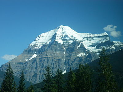
| 1 | Mount Robson | British Columbia | Canadian Rockies | 3959 m 12,989 ft | 2829 m 9,281 ft | 460 km 286 mi | 53.1105°N 119.1566°W |
| 2 | Mount Columbia |  Alberta British Columbia Alberta British Columbia | Canadian Rockies | 3741 m 12,274 ft | 2371 m 7,779 ft | 158 km 98.2 mi | 52.1473°N 117.4416°W |
| 3 | Ulysses Mountain | British Columbia | Muskwa Ranges | 3024 m 9,921 ft | 2294 m 7,526 ft | 436 km 271 mi | 57.3464°N 124.0928°W |
| 4 | Mount Assiniboine | Alberta British Columbia | Canadian Rockies | 3616 m 11,864 ft | 2082 m 6,831 ft | 141.8 km 88.1 mi | 50.8696°N 115.6509°W |
| 5 | Mount Edith Cavell | Alberta | Canadian Rockies | 3363 m 11,033 ft | 2033 m 6,670 ft | 47.2 km 29.3 mi | 52.6672°N 118.0569°W |
| 6 | Mount Goodsir | British Columbia | Canadian Rockies | 3567 m 11,703 ft | 1917 m 6,289 ft | 64.1 km 39.8 mi | 51.2021°N 116.3975°W |
| 7 | Mount Harrison | British Columbia | Canadian Rockies | 3360 m 11,024 ft | 1770 m 5,807 ft | 52.1 km 32.4 mi | 50.0604°N 115.2057°W |
| 8 | Mount Sir Alexander | British Columbia | Canadian Rockies | 3275 m 10,745 ft | 1762 m 5,781 ft | 87.8 km 54.5 mi | 53.9360°N 120.3869°W |
| 9 | Mount Hector | Alberta | Canadian Rockies | 3394 m 11,135 ft | 1759 m 5,771 ft | 21.5 km 13.34 mi | 51.5752°N 116.2590°W |
| 10 | Whitehorn Mountain | British Columbia | Canadian Rockies | 3399 m 11,152 ft | 1747 m 5,732 ft | 7.94 km 4.93 mi | 53.1370°N 119.2667°W |
| 11 | Mount Chown | Alberta | Canadian Rockies | 3316 m 10,879 ft | 1746 m 5,728 ft | 30.7 km 19.05 mi | 53.3971°N 119.4173°W |
| 12 | Jeanette Peak | British Columbia | Canadian Rockies | 3089 m 10,135 ft | 1657 m 5,436 ft | 20.3 km 12.6 mi | 52.6357°N 118.6166°W |
| 13 | Mount Forbes | Alberta | Canadian Rockies | 3617 m 11,867 ft | 1649 m 5,410 ft | 47.4 km 29.5 mi | 51.8600°N 116.9316°W |
| 14 | Mount Fryatt | Alberta | Canadian Rockies | 3361 m 11,027 ft | 1608 m 5,276 ft | 16.37 km 10.17 mi | 52.5503°N 117.9104°W |
| 15 | Mount Ovington | British Columbia | Hart Ranges | 2949 m 9,675 ft | 1600 m 5,249 ft | 18.75 km 11.65 mi | 54.1433°N 120.5740°W |
| 16 | Mount Sylvia | British Columbia | Muskwa Ranges | 2940 m 9,646 ft | 1559 m 5,115 ft | 84.9 km 52.8 mi | 58.0820°N 124.4688°W |
| 17 | Mount Crysdale | British Columbia | Misinchinka Ranges | 2429 m 7,969 ft | 1554 m 5,098 ft | 147.3 km 91.5 mi | 55.9383°N 123.4210°W |
| 18 | Mount Temple | Alberta | Canadian Rockies | 3540 m 11,614 ft | 1530 m 5,020 ft | 21.3 km 13.22 mi | 51.3511°N 116.2063°W |
| 19 | Mount Ida | British Columbia | Canadian Rockies | 3200 m 10,499 ft | 1530 m 5,020 ft | 14.14 km 8.79 mi | 54.0580°N 120.3268°W |
| 20 | Gataga Peak | British Columbia | Muskwa Ranges | 2533 m 8,310 ft | 1515 m 4,970 ft | 35.3 km 21.9 mi | 58.0697°N 125.7010°W |
| 21 | Mount Joffre | Alberta British Columbia | Canadian Rockies | 3433 m 11,263 ft | 1505 m 4,938 ft | 49.2 km 30.6 mi | 50.5285°N 115.2069°W |
US Coast Ranges
edit| Rank | Mountain Peak | Region | Mountain Range | Elevation | Prominence | Isolation | Location |
|---|---|---|---|---|---|---|---|
| 1 | Mount Olympus | Washington | Olympic Mountains | 2432 m 7,980 ft | 2389 m 7,838 ft | 173.7 km 108 mi | 47.8013°N 123.7108°W |
| 2 | Mount Eddy |  California California | Klamath Mountains | 2755 m 9,037 ft | 1571 m 5,153 ft | 23.5 km 14.58 mi | 41.3196°N 122.4790°W |
Cascade Range and Sierra Nevada
edit| Rank | Mountain Peak | Region | Mountain Range | Elevation | Prominence | Isolation | Location |
|---|---|---|---|---|---|---|---|
| 1 | Mount Rainier | Washington | Cascade Range | 4394 m 14,417 ft | 4034 m 13,236 ft | 1,177 km 731 mi | 46.8521°N 121.7579°W |
| 2 | Mount Whitney | California | Sierra Nevada | 4421 m 14,505 ft | 3072 m 10,079 ft | 2,649 km 1,646 mi | 36.5786°N 118.2920°W |
| 3 | Mount Shasta | California | Cascade Range | 4322 m 14,179 ft | 2997 m 9,832 ft | 539 km 335 mi | 41.4092°N 122.1949°W |
| 4 | Mount Baker | Washington | Cascade Range | 3287 m 10,786 ft | 2696 m 8,845 ft | 212 km 131.5 mi | 48.7768°N 121.8145°W |
| 5 | Mount Adams | Washington | Cascade Range | 3743 m 12,281 ft | 2480 m 8,136 ft | 73.6 km 45.8 mi | 46.2024°N 121.4909°W |
| 6 | Mount Hood |  Oregon Oregon | Cascade Range | 3429 m 11,249 ft | 2349 m 7,706 ft | 92.2 km 57.3 mi | 45.3735°N 121.6959°W |
| 7 | Glacier Peak | Washington | Cascade Range | 3214 m 10,545 ft | 2291 m 7,518 ft | 90.2 km 56 mi | 48.1125°N 121.1138°W |
| 8 | Silvertip Mountain | British Columbia | Cascade Range | 2596 m 8,517 ft | 1876 m 6,155 ft | 19.55 km 12.15 mi | 49.1633°N 121.2161°W |
| 9 | Mount Jefferson | Oregon | Cascade Range | 3201 m 10,502 ft | 1767 m 5,797 ft | 77.5 km 48.1 mi | 44.6743°N 121.7996°W |
| 10 | South Sister | Oregon | Cascade Range | 3159 m 10,363 ft | 1709 m 5,608 ft | 63.4 km 39.4 mi | 44.1035°N 121.7693°W |
| 11 | Mount Stuart | Washington | Cascade Range | 2871 m 9,420 ft | 1632 m 5,354 ft | 71.6 km 44.5 mi | 47.4751°N 120.9024°W |
| 12 | Lassen Peak | California | Cascade Range | 3189 m 10,462 ft | 1594 m 5,229 ft | 114.9 km 71.4 mi | 40.4882°N 121.5050°W |
Transverse Ranges and US Peninsular Ranges
edit| Rank | Mountain Peak | Region | Mountain Range | Elevation | Prominence | Isolation | Location |
|---|---|---|---|---|---|---|---|
| 1 | San Jacinto Peak | California | San Jacinto Mountains | 3302 m 10,834 ft | 2542 m 8,339 ft | 32.7 km 20.3 mi | 33.8147°N 116.6794°W |
| 2 | San Gorgonio Mountain | California | San Bernardino Mountains | 3506 m 11,503 ft | 2528 m 8,294 ft | 262 km 162.5 mi | 34.0992°N 116.8249°W |
| 3 | Mount San Antonio | California | San Gabriel Mountains | 3069 m 10,068 ft | 1903 m 6,244 ft | 68.4 km 42.5 mi | 34.2892°N 117.6464°W |
Intermontane Plateaus
edit| Rank | Mountain Peak | Region | Mountain Range | Elevation | Prominence | Isolation | Location |
|---|---|---|---|---|---|---|---|
| 1 | Charleston Peak (Mount Charleston) |  Nevada Nevada | Spring Mountains | 3632 m 11,916 ft | 2517 m 8,257 ft | 218 km 135.1 mi | 36.2716°N 115.6956°W |
| 2 | Wheeler Peak | Nevada | Snake Range | 3982 m 13,065 ft | 2307 m 7,568 ft | 373 km 232 mi | 38.9858°N 114.3139°W |
| 3 | White Mountain Peak | California | White Mountains | 4344 m 14,252 ft | 2193 m 7,196 ft | 108.6 km 67.4 mi | 37.6341°N 118.2557°W |
| 4 | Sacajawea Peak | Oregon | Wallowa Mountains | 3000 m 9,843 ft | 1944 m 6,377 ft | 202 km 125.5 mi | 45.2450°N 117.2929°W |
| 5 | Mount Graham |  Arizona Arizona | Pinaleño Mountains | 3269 m 10,724 ft | 1932 m 6,340 ft | 132.7 km 82.5 mi | 32.7017°N 109.8714°W |
| 6 | Telescope Peak | California | Panamint Range | 3366 m 11,043 ft | 1886 m 6,188 ft | 92 km 57.2 mi | 36.1698°N 117.0892°W |
| 7 | Humphreys Peak | Arizona | San Francisco Peaks | 3852 m 12,637 ft | 1841 m 6,039 ft | 396 km 246 mi | 35.3463°N 111.6779°W |
| 8 | Mount Jefferson | Nevada | Toquima Range | 3642 m 11,949 ft | 1789 m 5,869 ft | 158.7 km 98.6 mi | 38.7520°N 116.9268°W |
| 9 | Deseret Peak |  Utah Utah | Stansbury Mountains | 3364 m 11,035 ft | 1772 m 5,812 ft | 74.2 km 46.1 mi | 40.4595°N 112.6263°W |
| 10 | Mount Wrightson | Arizona | Santa Rita Mountains | 2881 m 9,452 ft | 1754 m 5,755 ft | 81 km 50.3 mi | 31.4144°N 110.5055°W |
| 11 | Pilot Peak | Nevada | Pilot Range | 3268 m 10,720 ft | 1747 m 5,731 ft | 88.3 km 54.9 mi | 41.0211°N 114.0774°W |
| 12 | Sierra Blanca Peak |  New Mexico New Mexico | Sierra Blanca | 3652 m 11,981 ft | 1693 m 5,553 ft | 267 km 166.2 mi | 33.3743°N 105.8087°W |
| 13 | North Schell Peak | Nevada | Schell Creek Range | 3624 m 11,888 ft | 1650 m 5,413 ft | 37.9 km 23.5 mi | 39.4132°N 114.5997°W |
| 14 | Hayford Peak | Nevada | Sheep Range | 3025 m 9,924 ft | 1650 m 5,412 ft | 55.8 km 34.7 mi | 36.6577°N 115.2008°W |
| 15 | Star Peak | Nevada | Humboldt Range | 2999 m 9,840 ft | 1646 m 5,400 ft | 111.2 km 69.1 mi | 40.5224°N 118.1708°W |
| 16 | Flat Top Mountain | Utah | Oquirrh Mountains | 3238 m 10,624 ft | 1640 m 5,382 ft | 38.4 km 23.8 mi | 40.3724°N 112.1888°W |
| 17 | Ibapah Peak | Utah | Deep Creek Range | 3686 m 12,093 ft | 1605 m 5,267 ft | 98.7 km 61.3 mi | 39.8282°N 113.9198°W |
| 18 | Arc Dome | Nevada | Toiyabe Range | 3591 m 11,781 ft | 1595 m 5,233 ft | 37.2 km 23.1 mi | 38.8327°N 117.3530°W |
| 19 | Mount Lemmon | Arizona | Santa Catalina Mountains | 2792 m 9,159 ft | 1578 m 5,177 ft | 82.9 km 51.5 mi | 32.4430°N 110.7885°W |
| 20 | Chiricahua Peak | Arizona | Chiricahua Mountains | 2976 m 9,763 ft | 1569 m 5,149 ft | 103.5 km 64.3 mi | 31.8465°N 109.2910°W |
| 21 | Miller Peak | Arizona | Huachuca Mountains | 2886 m 9,470 ft | 1527 m 5,011 ft | 107.6 km 66.8 mi | 31.3928°N 110.2930°W |
US Rocky Mountains
edit| Rank | Mountain Peak | Region | Mountain Range | Elevation | Prominence | Isolation | Location |
|---|---|---|---|---|---|---|---|
| 1 | Mount Elbert |  Colorado Colorado | Sawatch Range | 4401 m 14,440 ft | 2772 m 9,093 ft | 1,079 km 671 mi | 39.1178°N 106.4454°W |
| 2 | Cloud Peak |  Wyoming Wyoming | Bighorn Mountains | 4013 m 13,167 ft | 2157 m 7,077 ft | 233 km 145 mi | 44.3821°N 107.1739°W |
| 3 | Gannett Peak | Wyoming | Wind River Range | 4209 m 13,809 ft | 2157 m 7,076 ft | 467 km 290 mi | 43.1842°N 109.6542°W |
| 4 | Grand Teton | Wyoming | Teton Range | 4199 m 13,775 ft | 1995 m 6,545 ft | 111.6 km 69.4 mi | 43.7412°N 110.8024°W |
| 5 | Kings Peak | Utah | Uinta Mountains | 4120 m 13,518 ft | 1938 m 6,358 ft | 268 km 166.6 mi | 40.7659°N 110.3779°W |
| 6 | Mount Peale | Utah | La Sal Mountains | 3879 m 12,726 ft | 1884 m 6,181 ft | 117.8 km 73.2 mi | 38.4385°N 109.2292°W |
| 7 | Borah Peak |  Idaho Idaho | Lost River Range | 3861 m 12,668 ft | 1829 m 6,002 ft | 243 km 150.8 mi | 44.1374°N 113.7811°W |
| 8 | Mount Ellen[41] | Utah | Henry Mountains | 3513 m 11,527 ft | 1787 m 5,862 ft | 90.2 km 56 mi | 38.1089°N 110.8136°W |
| 9 | Crazy Peak |  Montana Montana | Crazy Mountains | 3418 m 11,214 ft | 1743 m 5,719 ft | 71.8 km 44.6 mi | 46.0182°N 110.2766°W |
| 10 | McDonald Peak | Montana | Mission Mountains | 2994 m 9,824 ft | 1722 m 5,650 ft | 127.9 km 79.5 mi | 47.3826°N 113.9191°W |
| 11 | Pikes Peak | Colorado | Pikes Peak Massif | 4302 m 14,115 ft | 1686 m 5,530 ft | 97.8 km 60.8 mi | 38.8405°N 105.0442°W |
| 12 | Mount Nebo | Utah | Wasatch Range | 3637 m 11,933 ft | 1679 m 5,508 ft | 121.7 km 75.6 mi | 39.8219°N 111.7603°W |
| 13 | Snowshoe Peak | Montana | Cabinet Mountains | 2665 m 8,742 ft | 1658 m 5,441 ft | 133.7 km 83.1 mi | 48.2231°N 115.6890°W |
| 14 | Diamond Peak | Idaho | Lemhi Range | 3719 m 12,202 ft | 1642 m 5,387 ft | 51.2 km 31.8 mi | 44.1414°N 113.0827°W |
| 15 | Blanca Peak | Colorado | Sangre de Cristo Range | 4374 m 14,351 ft | 1623 m 5,326 ft | 166.4 km 103.4 mi | 37.5775°N 105.4857°W |
| 16 | Mount Timpanogos | Utah | Wasatch Range | 3582 m 11,752 ft | 1609 m 5,279 ft | 63.9 km 39.7 mi | 40.3908°N 111.6459°W |
| 17 | Mount Cleveland | Montana | Canadian Rockies | 3194 m 10,479 ft | 1599 m 5,246 ft | 159.9 km 99.4 mi | 48.9249°N 113.8482°W |
Appalachian Mountains
edit| Rank | Mountain Peak | Region | Mountain Range | Elevation | Prominence | Isolation | Location |
|---|---|---|---|---|---|---|---|
| 1 | Mount Washington |  New Hampshire New Hampshire | White Mountains | 1917 m 6,288 ft | 1877 m 6,158 ft | 1,319 km 820 mi | 44.2705°N 71.3032°W |
| 2 | Mount Mitchell |  North Carolina North Carolina | Blue Ridge Mountains | 2037 m 6,684 ft | 1857 m 6,091 ft | 1,913 km 1,189 mi | 35.7650°N 82.2652°W |
Mexico
edit| Rank | Mountain Peak | Region | Mountain Range | Elevation | Prominence | Isolation | Location |
|---|---|---|---|---|---|---|---|
| 1 | Volcán Citlaltépetl (Pico de Orizaba) |  Puebla Puebla Veracruz Veracruz | Cordillera Neovolcanica | 5636 m 18,491 ft | 4922 m 16,148 ft | 2,690 km 1,672 mi | 19.0305°N 97.2698°W |
| 2 | Volcán Popocatépetl |  México México Morelos Puebla Morelos Puebla | Cordillera Neovolcanica | 5410 m 17,749 ft | 3040 m 9,974 ft | 143 km 88.8 mi | 19.0225°N 98.6278°W |
| 3 | Nevado de Colima |  Jalisco Jalisco | Cordillera Neovolcanica | 4270 m 14,009 ft | 2720 m 8,924 ft | 407 km 253 mi | 19.5629°N 103.6083°W |
| 4 | Nevado de Toluca (Volcán Xinantécatl) | México | Cordillera Neovolcanica | 4690 m 15,387 ft | 2225 m 7,300 ft | 118.4 km 73.6 mi | 19.1020°N 99.7676°W |
| 5 | Cerro Tiotepec (Cerro Teotepec) |  Guerrero Guerrero | Sierra Madre del Sur | 3550 m 11,647 ft | 2180 m 7,152 ft | 185 km 115 mi | 17.4667°N 100.1333°W |
| 6 | Cerro El Nacimiento (Cerro Nube Flane) |  Oaxaca Oaxaca | Sierra Madre del Sur | 3710 m 12,172 ft | 2140 m 7,021 ft | 1.58 km 0.98 mi | 16.2113°N 96.1967°W |
| 7 | Picacho del Diablo |  Baja California Baja California | Sierra de San Pedro Mártir | 3110 m 10,203 ft | 2140 m 7,021 ft | 334 km 208 mi | 30.9928°N 115.3752°W |
| 8 | Cerro Las Conchas |  Michoacán Michoacán | Michoacán | 2890 m 9,482 ft | 1960 m 6,430 ft | 104.5 km 65 mi | 18.7167°N 102.9667°W |
| 9 | Volcán Matlalcuéyetl (La Malinche) | Puebla Tlaxcala Tlaxcala | Cordillera Neovolcanica | 4430 m 14,534 ft | 1940 m 6,365 ft | 63.5 km 39.5 mi | 19.2500°N 98.0333°W |
| 10 | Sierra La Laguna High Point |  Baja California Sur Baja California Sur | Sierra La Laguna | 2090 m 6,857 ft | 1920 m 6,299 ft | 342 km 213 mi | 23.5399°N 109.9543°W |
| 11 | Sierra La Madera |  Coahuila Coahuila | Mexican Plateau | 3030 m 9,941 ft | 1905 m 6,250 ft | 227 km 140.9 mi | 27.0333°N 102.4000°W |
| 12 | Sierra de Minas Viejas |  Nuevo León Nuevo León | Sierra Madre Oriental | 2630 m 8,629 ft | 1885 m 6,184 ft | 55 km 34.2 mi | 26.1198°N 100.5569°W |
| 13 | Cerro El Potosí | Nuevo León | Sierra Madre Oriental | 3720 m 12,205 ft | 1875 m 6,152 ft | 570 km 354 mi | 24.8719°N 100.2327°W |
| 14 | Cerro La Joya |  Querétaro Querétaro | Sierra Madre Oriental | 2920 m 9,580 ft | 1870 m 6,135 ft | 65.6 km 40.8 mi | 21.4333°N 99.1333°W |
| 15 | Volcán Tancítaro | Michoacán | Cordillera Neovolcanica | 3840 m 12,598 ft | 1665 m 5,463 ft | 137.9 km 85.7 mi | 19.4167°N 102.3000°W |
| 16 | Picacho San Onofre (Sierra Peña Nevada) | Nuevo León | Sierra Madre Oriental | 3540 m 11,614 ft | 1640 m 5,381 ft | 125 km 77.6 mi | 23.8006°N 99.8466°W |
| 17 | Cerro El Centinela | Coahuila | Mexican Plateau | 3120 m 10,236 ft | 1640 m 5,381 ft | 186.6 km 115.9 mi | 25.1333°N 103.2333°W |
| 18 | El Aguacate Oeste | Oaxaca | Sierra Madre del Sur | 2820 m 9,252 ft | 1640 m 5,381 ft | 57.4 km 35.6 mi | 16.5833°N 95.8000°W |
| 19 | Volcán Las Tres Vírgenes | Baja California Sur | Tres Virgenes | 1950 m 6,398 ft | 1625 m 5,331 ft | 340 km 211 mi | 27.4712°N 112.5900°W |
| 20 | Sierra de Santa Martha | Veracruz | Cordillera Neovolcanica | 1690 m 5,545 ft | 1620 m 5,315 ft | 179.3 km 111.4 mi | 18.3833°N 94.8667°W |
| 21 | Cerro Las Capillas | Jalisco | Jalisco | 2890 m 9,482 ft | 1590 m 5,217 ft | 56 km 34.8 mi | 19.5500°N 104.1500°W |
| 22 | Sierra del Fraile | Nuevo León | Sierra Madre Oriental | 2390 m 7,841 ft | 1590 m 5,217 ft | 26.3 km 16.37 mi | 25.8652°N 100.6089°W |
| 23 | Cerro Zempoaltepetl | Oaxaca | Sierra Madre de Oaxaca | 3420 m 11,220 ft | 1580 m 5,184 ft | 107.5 km 66.8 mi | 17.1667°N 95.9833°W |
| 24 | Volcán Iztaccíhuatl | México Puebla | Cordillera Neovolcanica | 5230 m 17,159 ft | 1560 m 5,118 ft | 17.41 km 10.82 mi | 19.1792°N 98.6419°W |
| 25 | Volcán de Tequila | Jalisco | Jalisco | 2930 m 9,613 ft | 1530 m 5,020 ft | 63.4 km 39.4 mi | 20.7833°N 103.8500°W |
| 26 | Cerro Atravesado (Sierra el Cerro Azul) | Oaxaca | Oaxaca | 2310 m 7,579 ft | 1510 m 4,954 ft | 108.9 km 67.6 mi | 16.7667°N 94.4500°W |
Central America
edit| Rank | Mountain Peak | Region | Mountain Range | Elevation | Prominence | Isolation | Location |
|---|---|---|---|---|---|---|---|
| 1 | Volcán Tajumulco |  Guatemala Guatemala | Sierra Madre de Chiapas | 4220 m 13,845 ft | 3980 m 13,058 ft | 722 km 448 mi | 15.0445°N 91.9035°W |
| 2 | Chirripó Grande (Cerro Chirripó) |  Costa Rica Costa Rica | Cordillera de Talamanca | 3819 m 12,530 ft | 3726 m 12,224 ft | 864 km 537 mi | 09.4841°N 83.4887°W |
| 3 | Montaña de Santa Bárbara |  Honduras Honduras | Santa Bárbara | 2744 m 9,003 ft | 2084 m 6,837 ft | 73.8 km 45.9 mi | 14.9167°N 88.1167°W |
| 4 | Cerro Las Minas | Honduras | Lempira | 2849 m 9,347 ft | 2069 m 6,788 ft | 129.9 km 80.7 mi | 14.5333°N 88.6833°W |
| 5 | Volcán de Agua | Guatemala | Sierra Madre de Chiapas | 3761 m 12,339 ft | 1981 m 6,499 ft | 15.68 km 9.74 mi | 14.4667°N 90.7333°W |
| 6 | Alto Cuchumatanes | Guatemala | Sierra de los Cuchumatanes | 3837 m 12,589 ft | 1877 m 6,158 ft | 65.1 km 40.5 mi | 15.5167°N 91.5333°W |
| 7 | Volcán Irazú | Costa Rica | Cordillera Central, Costa Rica | 3402 m 11,161 ft | 1872 m 6,142 ft | 47.9 km 29.8 mi | 09.9770°N 83.8541°W |
| 8 | Montañas Peña Blanca | Guatemala | Sierra Madre de Chiapas | 3518 m 11,542 ft | 1858 m 6,096 ft | 42.1 km 26.1 mi | 15.5000°N 91.9167°W |
| 9 | Volcán Acatenango | Guatemala | Sierra Madre de Chiapas | 3975 m 13,041 ft | 1835 m 6,020 ft | 125.8 km 78.2 mi | 14.5000°N 90.8667°W |
| 10 | Volcán San Miguel |  El Salvador El Salvador | Sierra Madre de Chiapas | 2131 m 6,991 ft | 1831 m 6,007 ft | 63.8 km 39.6 mi | 13.4333°N 88.2667°W |
| 11 | Cerro Tacarcuna |  Panama Panama | Darién | 1875 m 6,152 ft | 1770 m 5,807 ft | 98.6 km 61.3 mi | 08.1667°N 77.3000°W |
| 12 | Volcán Atitlán | Guatemala | Sierra Madre de Chiapas | 3537 m 11,604 ft | 1754 m 5,755 ft | 34.6 km 21.5 mi | 14.5833°N 91.1833°W |
| 13 | Pico Bonito | Honduras | Cordillera Nombre de Dios | 2450 m 8,038 ft | 1710 m 5,610 ft | 152.2 km 94.6 mi | 15.5667°N 86.8667°W |
| 14 | Montaña San Ildefonso | Honduras | Cortés | 2242 m 7,356 ft | 1702 m 5,584 ft | 68.4 km 42.5 mi | 15.5167°N 88.2333°W |
| 15 | Volcán San Cristóbal |  Nicaragua Nicaragua | Cordillera Los Maribios | 1745 m 5,725 ft | 1665 m 5,463 ft | 134.2 km 83.4 mi | 12.7000°N 87.0167°W |
| 16 | Volcán de Santa Ana | El Salvador | Sierra Madre de Chiapas | 2362 m 7,749 ft | 1602 m 5,256 ft | 70.1 km 43.6 mi | 13.8500°N 89.6333°W |
| 17 | Volcán Concepción | Nicaragua | Rivas | 1610 m 5,282 ft | 1579 m 5,180 ft | 69.6 km 43.2 mi | 11.5333°N 85.6167°W |
| 18 | Pico Pijol | Honduras | Yoro | 2320 m 7,612 ft | 1578 m 5,177 ft | 66 km 41 mi | 15.1833°N 87.5667°W |
| 19 | Volcán de San Vicente | El Salvador | Sierra Madre de Chiapas | 2182 m 7,159 ft | 1562 m 5,125 ft | 90.5 km 56.2 mi | 13.6000°N 88.8333°W |
| 20 | Cerro El Pital | El Salvador Honduras | Sierra Madre de Chiapas | 2730 m 8,957 ft | 1530 m 5,020 ft | 49.1 km 30.5 mi | 14.3833°N 89.1167°W |
| 21 | Volcán Miravalles | Costa Rica | Cordillera de Guanacaste | 2028 m 6,654 ft | 1528 m 5,013 ft | 102.7 km 63.8 mi | 10.7333°N 85.1333°W |
| 22 | Montaña los Comayagua | Honduras | Comayagua | 2407 m 7,897 ft | 1507 m 4,944 ft | 80.9 km 50.3 mi | 14.5000°N 87.5000°W |
| 23 | Sierra de Agalta High Point | Honduras | Sierra de Agalta | 2335 m 7,661 ft | 1505 m 4,938 ft | 122.7 km 76.2 mi | 14.9500°N 85.9167°W |
Caribbean
edit| Rank | Mountain Peak | Region | Mountain Range | Elevation | Prominence | Isolation | Location |
|---|---|---|---|---|---|---|---|
| 1 | Pico Duarte |  Dominican Republic Dominican Republic | Cordillera Central, Dominican Republic | 3098 m 10,164 ft | 3098 m 10,164 ft | 941 km 584 mi | 19.0230°N 70.9981°W |
| 2 | Pic la Selle |  Haiti Haiti | Island of Hispaniola | 2680 m 8,793 ft | 2650 m 8,694 ft | 126.6 km 78.7 mi | 18.3601°N 71.9764°W |
| 3 | Blue Mountain Peak |  Jamaica Jamaica | Island of Jamaica | 2256 m 7,402 ft | 2256 m 7,402 ft | 273 km 169.4 mi | 18.0465°N 76.5788°W |
| 4 | Pic Macaya | Haiti | Island of Hispaniola | 2347 m 7,700 ft | 2087 m 6,847 ft | 217 km 134.6 mi | 18.3830°N 74.0256°W |
| 5 | Pico Turquino |  Cuba Cuba | Sierra Maestra | 1974 m 6,476 ft | 1974 m 6,476 ft | 217 km 134.7 mi | 19.9898°N 76.8360°W |
| 6 | Loma Gajo en Medio | Dominican Republic | Sierra de Neiba | 2279 m 7,477 ft | 1779 m 5,837 ft | 56.9 km 35.3 mi | 18.6358°N 71.5219°W |
| 7 | Loma Alto de la Bandera | Dominican Republic | Cordillera Central, Dominican Republic | 2842 m 9,324 ft | 1502 m 4,928 ft | 43.4 km 27 mi | 18.8123°N 70.6267°W |
Ultra-prominent summits
editThe following sortable table comprises the 353 ultra-prominent summits of greater North America.[j] Each of these peaks has at least 1500 meters (4921 feet) of topographic prominence.[k]
The summit of a mountain or hill may be measured in three principal ways:
- The topographic elevation of a summit measures the height of the summit above a geodetic sea level.[42][43]
- The topographic prominence of a summit is a measure of how high the summit rises above its surroundings.[44][43]
- The topographic isolation (or radius of dominance) of a summit measures how far the summit lies from its nearest point of equal elevation.[45]
Denali is one of only three summits on Earth with more than 6000 meters (19,685 feet) of topographic prominence. Mount Logan exceeds 5000 meters (16,404 feet) of prominence. Four peaks of greater North America exceed 4000 meters (13,123 feet), ten exceed 3500 meters (11,483 feet), 17 exceed 3000 meters (9843 feet), 34 exceed 2500 meters (8202 feet), 100 exceed 2000 meters (6562 feet), and the following 353 ultra-prominent summits exceed 1500 meters (4921 feet) of topographic prominence.
Of the 353 ultra-prominent summits of North America, 143 are located in Canada, 122 in the United States (excluding six in Hawaiʻi), 38 in Greenland, 26 in México, eight in Honduras, six in Guatemala, four in El Salvador, three in Costa Rica, three in the Dominican Republic, two in Haiti, two in Nicaragua, and one each in Jamaica, Cuba, and Panamá. Six of these peaks lie on the Canada-United States border and one lies on the El Salvador-Honduras border. Additional references for the 200 most prominent of these summits can be found on the List of the most prominent summits of North America.


Gallery
edit
 3. Pico de Orizaba is the highest summit of México.

 7. Chirripó Grande is the highest summit of Costa Rica.

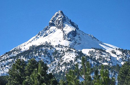
 10. Mount Hayes is the highest summit of the eastern Alaska Range.
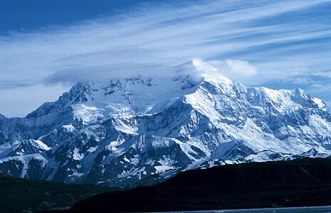


 17. Popocatépetl is the second highest summit of México.
 22. Redoubt Volcano is the highest summit of the Aleutian Range.


 49. Mount Hood is the highest summit of Oregon.
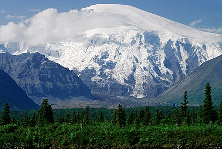
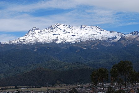
 61. Nevado de Toluca is the fourth highest summit of México.
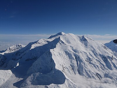 64. Mount Foraker is the second highest major summit of the Alaska Range.


 310. Iztaccihuatl is the third highest summit of México.


Gallery
edit-
-
- 3. Pico de Orizaba is the highest peak of Mexico.
-
-
- 7. Cerro Chirripó is the highest peak of Costa Rica.

-
-


-
- 17. Popocatépetl is the second highest peak of Mexico.
-


- 22. Redoubt Volcano is the highest peak of the Alaskan Peninsula.
-
 25. Nevado de Colima is the highest peak of Jalisco.


See also
edit


- List of mountain peaks of North America
- List of the highest major summits of North America
- List of the most isolated major summits of North America
- List of mountain peaks of Greenland
- List of mountain peaks of Canada
- List of mountain peaks of the Rocky Mountains
- List of mountain peaks of the United States
- List of mountain peaks of México
- List of mountain peaks of Central America
- List of mountain peaks of the Caribbean
- North America
- Physical geography
Notes
edit- ^ a b The summit of Gunnbjørn Fjeld is the highest point of the Island of Greenland, Kalaallit Nunaat, the Kingdom of Denmark, and the entire Arctic.
- ^ a b The summit of Pyramiden is the highest point of Disko Island.
- ^ a b The summit of Angelin Bjerg is the highest point of Ymer Island.
- ^ a b The summit of Snehaetten is the highest point of the Qeqertaq Island.
- ^ a b The summit of Azimuthbjerg is the highest point of the island of Skjoldungen.
- ^ a b The summit of Svedenborg Bjerg is the highest point of Geographical Society Island.
- ^ a b The summit of Appaalik is the highest point of Appat Island.
- ^ a b The apex of Hahn Land is the easternmost ultra-prominent summit of Greenland and greater North America.
- ^ a b The apex of the Nuussuaq Peninsula is the westernmost 2000-meter (6562-foot) summit in Greenland.
- ^ This article defines greater North America as the portion of the continental landmass of the Americas extending westward and northward from the Isthmus of Panama plus the ocean islands surrounding that landmass. This article defines the ocean islands of greater North America to include the coastal islands of North America, the islands of the Caribbean Sea, the Lucayan Archipelago, the islands of Greenland (Kalaallit Nunaat), the islands of Canada, and the islands of Alaska. The Hawaiian Islands are not included because they are considered part of Oceania.
- ^ This article defines a significant summit as a summit with at least 100 meters (328.1 feet) of topographic prominence, and a major summit as a summit with at least 500 meters (1640 feet) of topographic prominence. An ultra-prominent summit is a summit with at least 1500 meters (4921 feet) of topographic prominence.
- ^ The summit of Denali is the highest point of the Alaska Range, the State of Alaska, the United States of America, and greater North America. Denali is the third most topographically prominent and third most topographically isolated summit on Earth after Mount Everest and Aconcagua.
- ^ The summit of Mount Logan is the highest point of the Saint Elias Mountains, Yukon, and all of Canada.
- ^ The summit of Pico de Orizaba is the highest point of Estado Libre y Soberano de Puebla, Estado Libre y Soberano de Veracruz de Ignacio de la Llave, and all of México.
- ^ The summit of Mount Rainier is the highest point of the Cascade Range and the U.S. State of Washington. Mount Rainier is the most prominent summit in the contiguous United States and the fourth most prominent in North America.
- ^ The elevation of Mount Rainier includes an adjustment of +1.914 m (6.28 ft) from NGVD 29 to NAVD 88.
- ^ The summit of Volcán Tajumulco is the highest point of the Sierra de las Nubes, the Republic of Guatemala, and all of Central America.
- ^ The summit of Chirripó Grande is the highest point of the Republic of Costa Rica.
- ^ The summit of Mount Blackburn is the highest point of the Wrangell Mountains.
- ^ The summit of Mount Hayes is the highest point of the Hayes Range.
- ^ The summit of Mount Waddington is the highest point of the Coast Mountains.
- ^ The summit of Mount Marcus Baker is the highest point of the Chugach Mountains.
- ^ The summit of Pico Duarte is the highest point of the Dominican Republic, the Island of Hispaniola, and all islands of the Caribbean Sea.
- ^ The summit of Mount Lucania is the highest point of the northern Saint Elias Mountains.
- ^ The summit of Mount Whitney is the highest point of the Sierra Nevada, the State of California, and the contiguous United States.
- ^ The summit of Mount Shasta is the highest point of the southern Cascade Range.
- ^ The summit of Monarch Mountain is the highest point of the Monarch Icefield.
- ^ The summit of Shishaldin Volcano is the highest point of Unimak Island and the Aleutian Islands.
- ^ The summit of Mount Robson is the highest point of the Canadian Rockies.
- ^ The summit of Redoubt Volcano is the highest point of the Chigmit Mountains.
- ^ The summit of Mount Elbert is the highest point of the U.S. State of Colorado, the Rocky Mountains of North America, and the entire Mississippi River drainage basin.
- ^ The summit of Mount Sir Wilfrid Laurier is the highest point of the Cariboo Mountains.
- ^ The summit of Nevado de Colima is the highest point of Estado Libre y Soberano de Jalisco.
- ^ The summit of Mount Sir Sandford is the highest point of the Columbia Mountains.
- ^ The summit of Mount Baker is the highest point of the northern Cascade Range.
- ^ The elevation of Mount Baker includes an adjustment of +1.43 m (4.69 ft) from NGVD 29 to NAVD 88.
- ^ The summit of Mount Torbert is the highest point of the Tordrillo Mountains.
- ^ The summit of Pic la Selle is the highest point of the Republic of Haiti.
- ^ The summit of Barbeau Peak is the highest point of Ellesmere Island and Nunavut of Canada.
- ^ The summit of San Jacinto Peak is the highest point of the San Jacinto Mountains.
- ^ The summit of San Gorgonio Mountain is the highest point of the San Bernardino Mountains.
- ^ The elevation of San Gorgonio Mountain includes an adjustment of +1.303 m (4.27 ft) from NGVD 29 to NAVD 88.
- ^ The summit of Charleston Peak is the highest point of the Spring Mountains.
- ^ The summit of Mount Pavlof is the highest point of the Alaska Peninsula.
- ^ The summit of Mount Veniaminof is the highest point of the Alaska Peninsula.
- ^ The summit of Skihist Mountain is the highest point of the Lillooet Range.
- ^ The summit of Mount Ratz is the highest point of the Boundary Ranges.
- ^ The summit of Mount Odin is the highest point of the Gold Range.
- ^ The summit of Mount Isto is the highest point of the Brooks Range.
- ^ The summit of Mount Monashee is the highest point of the Monashee Mountains.
- ^ The summit of Mount Olympus is the highest point of the Olympic Mountains.
- ^ The summit of Mount Queen Bess is the highest point of the Homathko Icefield.
- ^ The summit of Mount Hood is the highest point of the Oregon Cascades and the U.S. State of Oregon.
- ^ The summit of Mount Cooper is the highest point of the Goat Range.
- ^ The summit of Wheeler Peak is the highest point of the Snake Range.
- ^ The summit of Ulysses Mountain is the highest point of the Far Northern Rockies.
- ^ Ulysses Mountain is the northernmost 3000-metre (9843-foot) summit of the Rocky Mountains.
- ^ The elevation of Glacier Peak includes an adjustment of +1.492 m (4.9 ft) from NGVD 29 to NAVD 88.
- ^ The summit of Mount Kimball is the highest point of the Delta Range.
- ^ The summit of Outlook Peak is the highest point of Axel Heiberg Island.
- ^ The summit of Golden Hinde is the highest point of Vancouver Island.
- ^ The summit of White Mountain Peak is the highest point of the White Mountains.
- ^ The summit of Cerro Teotepec is the highest point of Estado Libre y Soberano de Guerrero.
- ^ The summit of Keele Peak is the highest point of the Mackenzie Mountains.
- ^ The summit of Cloud Peak is the highest point of the Bighorn Mountains.
- ^ The summit of Gannett Peak is the highest point of the Wind River Range, the U.S. State of Wyoming, and the central Rocky Mountains.
- ^ The summit of Razorback Mountain is the highest point of the Niut Range.
- ^ The summit of Mount Vsevidof is the highest point of Umnak Island.
- ^ The summit of Mount Odin is the highest point of Baffin Island.
- ^ The summit of Cerro el Nacimiento is the highest point of Sierra Madre del Sur and Estado Libre y Soberano de Oaxaca.
- ^ The summit of Mount Hesperus is the highest point of the western Alaska Range.
- ^ The summit of Mount Farnham is the highest point of the Purcell Mountains.
- ^ The summit of Mount Bona is the highest point of the northwest Saint Elias Mountains.
- ^ The summit of Cerro Las Minas is the highest point of the Republic of Honduras.
- ^ The summit of Grand Teton is the highest point of the Teton Range.
- ^ The summit of Pico Turquino is the highest point of the island and Republic of Cuba.
- ^ The summit of Sacajawea Peak is the highest point of the Wallowa Mountains and the Columbia Plateau.
- ^ The elevation of Sacajawea Peak includes an adjustment of +1.56 m (5.12 ft) from NGVD 29 to NAVD 88.
- ^ The summit of Angilaaq Mountain is the highest point of Bylot Island.
- ^ The summit of Mount Neacola is the highest point of the Neacola Mountains.
- ^ The summit of Kings Peak is the highest point of the Uinta Mountains, the U.S. State of Utah, and the western Rocky Mountains.
- ^ The elevation of Kings Peak includes an adjustment of +1.807 m (5.93 ft) from NGVD 29 to NAVD 88.
- ^ The summit of Mount Graham is the highest point of the Pinaleño Mountains.
- ^ The summit of Devon Ice Cap High Point is the highest point of Devon Island.
- ^ The summit of Pico La Laguna is the highest point of Sierra San Lazaro and Estado Libre y Soberano de Baja California Sur.
- ^ The summit of Mount Goodsir is the highest point of the Ottertail Range.
- ^ The summit of Mount San Antonio is the highest point of the San Gabriel Mountains.
- ^ The elevation of Mount San Antonio includes an adjustment of +1.214 m (3.98 ft) from NGVD 29 to NAVD 88.
- ^ The summit of Telescope Peak is the highest point of the Panamint Range.
- ^ The summit of Mount Peale is the highest point of the La Sal Mountains and the Colorado Plateau.
- ^ The summit of Mount Washington is the highest point of the White Mountains, the State of New Hampshire, and the northeastern United States.
- ^ The summit of Cerro El Potosí is the highest point of Estado Libre y Soberano de Nuevo León.
- ^ The summit of Mount Igikpak is the highest point of the Schwatka Mountains.
- ^ The summit of Silvertip Mountain is the highest point of the Hope Mountains.
- ^ The summit of Mount Mitchell is the highest point of the Appalachian Mountains, the State of North Carolina, and the eastern United States.
- ^ The summit of Truuli Peak is the highest point of the Kenai Mountains.
- ^ The summit of Humphreys Peak is the highest point of the San Francisco Peaks and the U.S. State of Arizona.
- ^ The elevation of Humphreys Peak includes an adjustment of +1.345 m (4.41 ft) from NGVD 29 to NAVD 88.
- ^ The summit of Borah Peak is the highest point of the Lost River Range and the U.S. State of Idaho.
- ^ The summit of Howson Peak is the highest point of the Hazleton Mountains.
- ^ The summit of Tanaga Volcano is the highest point of Tanaga Island and the Andreanof Islands.
- ^ The summit of Kootenay Mountain is the highest point of the Nelson Range.
- ^ The summit of Makushin Volcano is the highest point of Unalaska Island.
- ^ The summit of Shedin Peak is the highest point of the Skeena Mountains.
- ^ The summit of Sovereign Mountain is the highest point of the Talkeetna Mountains.
- ^ The summit of Mount Jefferson is the highest point of the Toquima Range.
- ^ The elevation of Mount Jefferson includes an adjustment of +1.666 m (5.47 ft) from NGVD 29 to NAVD 88.
- ^ The summit of Mount Ellen is the highest point of the Henry Mountains.
- ^ The elevation of Mount Ellen includes an adjustment of +1.486 m (4.88 ft) from NGVD 29 to NAVD 88.
- ^ The summit of Deseret Peak is the highest point of the Stansbury Mountains.
- ^ The elevation of Mount Jefferson includes an adjustment of +1.388 m (4.55 ft) from NGVD 29 to NAVD 88.
- ^ The summit of Pilot Peak is the highest point of the Pilot Range.
- ^ The summit of Crazy Peak is the highest point of the Crazy Mountains.
- ^ The elevation of Crazy Peak includes an adjustment of +1.421 m (4.66 ft) from NGVD 29 to NAVD 88.
- ^ The summit of Great Sitkin Volcano is the highest point of Great Sitkin Island.
- ^ The summit of Thudaka Peak is the highest point of Cassiar Mountains.
- ^ The summit of Mount Cleveland is the highest point of Chuginadak Island.
- ^ The summit of McDonald Peak is the highest point of the Mission Range.
- ^ The elevation of McDonald Peak includes an adjustment of +1.318 m (4.32 ft) from NGVD 29 to NAVD 88.
- ^ The summit of Cond Peak is the highest point of the Kokanee Range.
- ^ The summit of Devils Paw is the highest point of the Juneau Icefield.
- ^ The summit of Sierra Blanca Peak is the highest point of the Sacramento Mountains.
- ^ The summit of Overseer Mountain is the highest point of the Pemberton Icefield.
- ^ The summit of Farquhar Peak is the highest point of King Island.
- ^ The summit of Mount Nebo is the highest point of the Wasatch Range.
- ^ The elevation of Mount Nebo includes an adjustment of +1.395 m (4.58 ft) from NGVD 29 to NAVD 88.
- ^ The summit of North Pinnacle is the highest point of the Whatshan Range.
- ^ The summit of Volcán Tancítaro is the highest point of Estado Libre y Soberano de Michoacán de Ocampo.
- ^ The summit of Mount Nirvana is the highest point of the Northwest Territories of Canada.
- ^ The summit of Sillem Peak is the highest point of Sillem Island.
- ^ The summit of Snowshoe Peak is the highest point of the Cabinet Mountains.
- ^ The elevation of Snowshoe Peak includes an adjustment of +1.367 m (4.48 ft) from NGVD 29 to NAVD 88.
- ^ The summit of North Schell Peak is the highest point of the Schell Creek Range.
- ^ The summit of Hayford Peak is the highest point of the Sheep Range.
- ^ The summit of Mount Forbes is the highest point of the entire Hudson Bay drainage basin.
- ^ The summit of Star Peak is the highest point of the Humboldt Range.
- ^ The summit of Veniaminof Peak is the highest point of Baranof Island.
- ^ The summit of Diamond Peak is the highest point of the Lemhi Range.
- ^ The summit of Flat Top Mountain is the highest point of the Oquirrh Mountains.
- ^ The elevation of Flat Top Mountain includes an adjustment of +1.329 m (4.36 ft) from NGVD 29 to NAVD 88.
- ^ The summit of Bearhole Peak is the highest point of the Granite Range.
- ^ The summit of Mount Steller is the highest point of Waxell Ridge.
- ^ The summit of Mount Stuart is the highest point of the Wenatchee Mountains.
- ^ The elevation of Mount Stuart includes an adjustment of +1.388 m (4.55 ft) from NGVD 29 to NAVD 88.
- ^ The summit of Blanca Peak is the highest point of the Sangre de Cristo Mountains and the entire Rio Grande drainage basin.
- ^ The summit of Mount Miller is the highest point of Barkley Ridge.
- ^ The summit of Carlisle Volcano is the highest point of Carlisle Island.
- ^ The summit of Mount Timpanogos is the highest point of the central Wasatch Range.
- ^ The summit of Mount Fryatt is the highest point of the Hooker Icefield.
- ^ The summit of Bashful Peak is the highest point of the western Chugach Mountains.
- ^ The summit of Ibapah Peak is the highest point of the Deep Creek Range.
- ^ The elevation of Ibapah Peak includes an adjustment of +1.517 m (4.98 ft) from NGVD 29 to NAVD 88.
- ^ The summit of Monmouth Mountain is the highest point of the Lillooet Icefield.
- ^ The summit of Mount Cleveland is the highest point of the Lewis Range.
- ^ The summit of She Devil (mountain) is the highest point of the Seven Devils Mountains.
- ^ The elevation of She Devil (mountain) includes an adjustment of +1.365 m (4.48 ft) from NGVD 29 to NAVD 88.
- ^ The summit of Arc Dome is the highest point of the Toiyabe Range.
- ^ The elevation of Arc Dome includes an adjustment of +1.665 m (5.46 ft) from NGVD 29 to NAVD 88.
- ^ The summit of Mount Addenbroke is the highest point of East Redonda Island and the Inside Passage Islands.
- ^ The summit of Mount Seton is the highest point of the Cayoosh Range.
- ^ The elevation of Abercrombie Mountain includes an adjustment of +1.345 m (4.41 ft) from NGVD 29 to NAVD 88.
- ^ The summit of Mount Lemmon is the highest point of the Santa Catalina Mountains.
- ^ The elevation of Mount Lemmon includes an adjustment of +1.004 m (3.29 ft) from NGVD 29 to NAVD 88.
- ^ The summit of Gareloi Volcano is the highest point of Gareloi Island.
- ^ Gareloi Volcano is the westernmost ultra-prominent summit of Alaska, the United States, and greater North America.
- ^ The summit of Chiricahua Peak is the highest point of the Chiricahua Mountains.
- ^ The elevation of Chiricahua Peak includes an adjustment of +1.173 m (3.85 ft) from NGVD 29 to NAVD 88.
- ^ The summit of Mount Eddy is the highest point of the Klamath Mountains.
- ^ The summit of Mount Wotzke is the highest point of the Quesnel Highland.
- ^ The summit of Mount Macdonald is the highest point of the Bonnet Plume Mountains.
- ^ The summit of Korovin Volcano is the highest point of Atka Island.
- ^ The summit of Whitecap Mountain is the highest point of the Bendor Range.
- ^ The summit of Dunn Peak is the highest point of the Shuswap Highland.
- ^ The summit of Mount Temple is the highest point of the Bow Range.
- ^ The summit of Miller Peak is the highest point of the Huachuca Mountains.
- ^ The elevation of Miller Peak includes an adjustment of +1.067 m (3.5 ft) from NGVD 29 to NAVD 88.
- ^ The summit of Pass Mountain is the highest point of the Wernecke Mountains.
References
edit- ^ "Gunnbjørn Fjeld". Peakbagger.com. Retrieved 4 May 2016.
- ^ "Gunnbjørn Fjeld". Bivouac.com. Retrieved 4 May 2016.
- ^ "Stauning Alper". Peakbagger.com. Retrieved 4 May 2016.
- ^ "Palup Qaqa high point". Peakbagger.com. Retrieved 4 May 2016.
- ^ "Milne Land high point". Peakbagger.com. Retrieved 4 May 2016.
- ^ "Payers Tinde". Peakbagger.com. Retrieved 4 May 2016.
- ^ "Perserajoq". Peakbagger.com. Retrieved 4 May 2016.
- ^ "Renland high point". Peakbagger.com. Retrieved 4 May 2016.
- ^ "Pyramiden". Peakbagger.com. Retrieved 4 May 2016.
- ^ "Angelin Bjerg". Peakbagger.com. Retrieved 4 May 2016.
- ^ "Traill Island high point". Peakbagger.com. Retrieved 4 May 2016.
- ^ "Parnaqussuit Qavaat high point". Peakbagger.com. Retrieved 4 May 2016.
- ^ "Storo high point". Peakbagger.com. Retrieved 4 May 2016.
- ^ "Snehaetten". Peakbagger.com. Retrieved 4 May 2016.
- ^ "Azimuthbjerg". Peakbagger.com. Retrieved 4 May 2016.
- ^ "Svedenborg Bjerg". Peakbagger.com. Retrieved 4 May 2016.
- ^ "Appaalik". Peakbagger.com. Retrieved 4 May 2016.
- ^ "Hahn Land high point". Peakbagger.com. Retrieved 4 May 2016.
- ^ "Nuussuaq high point". Peakbagger.com. Retrieved 4 May 2016.
- ^ "Hardersbjerg". Peakbagger.com. Retrieved 4 May 2016.
- ^ "Klosterbjerge". Peakbagger.com. Retrieved 4 May 2016.
- ^ "Qingagssat Qaqit". Peakbagger.com. Retrieved 4 May 2016.
- ^ "Ejnar Mikkelsen Fjeld". Peakbagger.com. Retrieved 4 May 2016.
- ^ "Agssaussat". Peakbagger.com. Retrieved 4 May 2016.
- ^ "Kloftbjerge". Peakbagger.com. Retrieved 4 May 2016.
- ^ "Salliaruseq high point". Peakbagger.com. Retrieved 4 May 2016.
- ^ "Clavering Island high point". Peakbagger.com. Retrieved 4 May 2016.
- ^ "Schweizerland high point". Peakbagger.com. Retrieved 4 May 2016.
- ^ "Margaretatopp". Peakbagger.com. Retrieved 4 May 2016.
- ^ "Paatuut". Peakbagger.com. Retrieved 4 May 2016.
- ^ "Agdleruussakasit". Peakbagger.com. Retrieved 4 May 2016.
- ^ "Mont Forel". Peakbagger.com. Retrieved 4 May 2016.
- ^ "Blaskbjerg". Peakbagger.com. Retrieved 4 May 2016.
- ^ "Kinaussak". Peakbagger.com. Retrieved 4 May 2016.
- ^ "Gaaseland high point". Peakbagger.com. Retrieved 4 May 2016.
- ^ "Sangmissoq high point". Peakbagger.com. Retrieved 4 May 2016.
- ^ "Favres Bjerg". Peakbagger.com. Retrieved 4 May 2016.
- ^ "Johnstrup Bjerge". Peakbagger.com. Retrieved 4 May 2016.
- ^ "Berzelius Bjerg". Peakbagger.com. Retrieved 4 May 2016.
- ^ "Denali". Peakbagger.com. Retrieved September 4, 2015.
- ^ "Mount Ellen". Peakbagger.com. Retrieved June 13, 2015.
- ^ All elevations in the 48 states of the contiguous United States include an elevation adjustment from the National Geodetic Vertical Datum of 1929 (NGVD 29) to the North American Vertical Datum of 1988 (NAVD 88). For further information, please see this United States National Geodetic Survey note.
- ^ a b If the elevation or prominence of a summit is calculated as a range of values, the arithmetic mean is shown.
- ^ The topographic prominence of a summit is the topographic elevation difference between the summit and its highest or key col to a higher summit. The summit may be near its key col or quite far away. The key col for Denali in Alaska is the Isthmus of Rivas in Nicaragua, 7642 kilometers (4749 miles) away.
- ^ The topographic isolation of a summit is the great-circle distance to its nearest point of equal elevation.
- ^ "MT BLACKBURN". Datasheet for NGS Station UV4136. U.S. National Geodetic Survey. Retrieved 4 May 2016.
- ^ "MT SHASTA". Datasheet for NGS Station MX1016. U.S. National Geodetic Survey. Retrieved 4 May 2016.
- ^ "MOUNT ELBERT". Datasheet for NGS Station KL0637. U.S. National Geodetic Survey. Retrieved 4 May 2016.
- ^ "SAN JACINTO". Datasheet for NGS Station DX5119. U.S. National Geodetic Survey. Retrieved 4 May 2016.
- ^ "CHARLESTON". Datasheet for NGS Station GR1965. U.S. National Geodetic Survey. Retrieved 4 May 2016.
- ^ "MOUNT ADAMS". Datasheet for NGS Station SB1004. U.S. National Geodetic Survey. Retrieved 4 May 2016.
- ^ "MT OLYMPUS". Datasheet for NGS Station SY1857. U.S. National Geodetic Survey. Retrieved 4 May 2016.
- ^ "MOUNT HOOD HIGHEST POINT". Datasheet for NGS Station RC2244. U.S. National Geodetic Survey. Retrieved 4 May 2016.
- ^ "WHEELER PEAK". Datasheet for NGS Station JP0339. U.S. National Geodetic Survey. Retrieved 4 May 2016.
- ^ "GLACIER PEAK". Datasheet for NGS Station TQ0506. U.S. National Geodetic Survey. Retrieved 4 May 2016.
- ^ "WHITE MOUNTAIN PEAK". Datasheet for NGS Station HR2559. U.S. National Geodetic Survey. Retrieved 4 May 2016.
- ^ "GANNETT PEAK CAIRN". Datasheet for NGS Station OW0356. U.S. National Geodetic Survey. Retrieved 4 May 2016.
- ^ "GRAHAM". Datasheet for NGS Station CY1235. U.S. National Geodetic Survey. Retrieved 4 May 2016.
- ^ "TELESCOPE". Datasheet for NGS Station GS0799. U.S. National Geodetic Survey. Retrieved 4 May 2016.
- ^ "MOUNT PEALE". Datasheet for NGS Station JM0496. U.S. National Geodetic Survey. Retrieved 4 May 2016.
- ^ "POGROMNI VOLCANO". Datasheet for NGS Station UV9965. U.S. National Geodetic Survey. Retrieved 4 May 2016.
- ^ "BEAUTY RESET". Datasheet for NGS Station PZ0770. U.S. National Geodetic Survey. Retrieved 4 May 2016.
- ^ "HANAGITA PEAK". Datasheet for NGS Station UV3837. U.S. National Geodetic Survey. Retrieved 4 May 2016.
- ^ "MOUNT JEFFERSON". Datasheet for NGS Station QD1739. U.S. National Geodetic Survey. Retrieved 4 May 2016.
- ^ "PILOT PEAK". Datasheet for NGS Station MT0738. U.S. National Geodetic Survey. Retrieved 4 May 2016.
- ^ "MOUNT CLEVELAND". Datasheet for NGS Station UV9122. U.S. National Geodetic Survey. Retrieved 4 May 2016.
- ^ "SOUTH SISTER". Datasheet for NGS Station QD1872. U.S. National Geodetic Survey. Retrieved 4 May 2016.
- ^ "SIERRA BLANCA". Datasheet for NGS Station DR1010. U.S. National Geodetic Survey. Retrieved 4 May 2016.
- ^ "NORTH SHELL". Datasheet for NGS Station KP0332. U.S. National Geodetic Survey. Retrieved 4 May 2016.
- ^ "HAYFORD". Datasheet for NGS Station GR1917. U.S. National Geodetic Survey. Retrieved 4 May 2016.
- ^ "STAR PEAK RESET". Datasheet for NGS Station LS0554. U.S. National Geodetic Survey. Retrieved 4 May 2016.
- ^ "DIAMOND RESET". Datasheet for NGS Station PZ0750. U.S. National Geodetic Survey. Retrieved 4 May 2016.
- ^ "MOUNT STUART". Datasheet for NGS Station SX1189. U.S. National Geodetic Survey. Retrieved 4 May 2016.
- ^ "CARLISLE PEAK". Datasheet for NGS Station TT5510. U.S. National Geodetic Survey. Retrieved 4 May 2016.
- ^ "TIMPANOGOS". Datasheet for NGS Station LO0769. U.S. National Geodetic Survey. Retrieved 4 May 2016.
- ^ "CLEVELAND". Datasheet for NGS Station TM1009. U.S. National Geodetic Survey. Retrieved 4 May 2016.
- ^ "LASSEN". Datasheet for NGS Station LT0688. U.S. National Geodetic Survey. Retrieved 4 May 2016.
- ^ "GARELOI VOLCANO". Datasheet for NGS Station TT5136. U.S. National Geodetic Survey. Retrieved 4 May 2016.
- ^ "EDDY". Datasheet for NGS Station MX1043. U.S. National Geodetic Survey. Retrieved 4 May 2016.
External links
edit Definitions from Wiktionary
 Media from Commons
 News from Wikinews
 Quotations from Wikiquote
 Texts from Wikisource
 Textbooks from Wikibooks
 Resources from Wikiversity
- Natural Resources Canada (NRC)
- Instituto Nacional de Estadística, Geografía e Informática (INEGI) de México
- National Geodetic Survey (NGS)
- United States Geological Survey (USGS)
- Canadian Mountain Encyclopedia @ bivouac.com
- North America @ peakbagger.com
- World Mountain Encyclopedia @ peakware.com
- peaklist.org
- summitpost.org