Voerendaal (Dutch pronunciation: [ˈvuːrə(n)daːl] ; Limburgish: Voelender) is a municipality and a town in the southeastern Netherlands.
Voerendaal Voelender | |
|---|---|
 Town of Voerendaal | |
 Flag  Coat of arms | |
.svg) Location in Limburg | |
| Coordinates: 50°53′N 5°56′E / 50.883°N 5.933°E | |
| Country | Netherlands |
| Province | Limburg |
| Government | |
| • Body | Municipal council |
| • Mayor | Wil Houben (VVD) |
| Area | |
| • Total | 31.52 km2 (12.17 sq mi) |
| • Land | 31.51 km2 (12.17 sq mi) |
| • Water | 0.01 km2 (0.004 sq mi) |
| Elevation | 92 m (302 ft) |
| Population (January 2021)[4] | |
| • Total | 12,466 |
| • Density | 396/km2 (1,030/sq mi) |
| Demonym | Voerendaler |
| Time zone | UTC+1 (CET) |
| • Summer (DST) | UTC+2 (CEST) |
| Postcode | 6310–6312, 6343, 6367 |
| Area code | 045 |
| Website | www |
Population centres
edit- Barrier
- Colmont
- Craubeek
- Dolberg
- Fromberg
- Heek
- Hellebeuk
- Klimmen
- Koulen
- Kunrade
- Mingersberg
- Opscheumer
- Overheek
- Ransdaal
- Retersbeek
- Termaar
- Termoors
- Ubachsberg
- Voerendaal
- Weustenrade
- Winthagen

Dutch topographic map of the municipality of Voerendaal, June 2015
History
editThe Romans left the ruins from a Roman villa rustica as a legacy. In 1049 pope Leo IX initiated the Catholic Church - Sint Laurentiuskerk. During medieval times many castles were built: Cortenbach, Haeren, Puth, Rivieren and Terworm. Also castles such as Hoenshuis and Overst Voerendaal. The area was mined for marl (mergel in Dutch) and coal.
Transportation
editRailway Station:Klimmen-Ransdaal, Voerendaal
Notable people
edit- Roel Brouwers (born 1981) a Dutch former footballer with 289 club caps, lived in Voerendaal while playing for Borussia Monchengladbach
Gallery
edit Church: Sint Laurentiuskerk
 Monument near church
 Cortenbach Castle
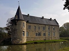 Rivieren Castle - Voerendaal

.JPG)
.JPG)

References
editExternal links
edit Media related to Voerendaal at Wikimedia Commons
- Official website
.svg) | This Dutch Limburg location article is a stub. You can help Wikipedia by expanding it. |
🔥 Top keywords: Akademia e Shkencave e RPS te ShqiperiseAlexandria Ocasio-CortezBilderberg GroupCristiano RonaldoDong XiaowanMinecraftOperation GladioPrimal cutRiot FestStrictly Come Dancing (series 7)Main PageSpecial:SearchWikipedia:Featured picturesUEFA Euro 2024Donald SutherlandJacob FatuInside Out 2CleopatraUFC on ABC: Whittaker vs. AliskerovDeaths in 2024List of teams that have overcome 3–0 series deficitsCristiano RonaldoUEFA European ChampionshipChappell RoanJessica AlbaSam FatuHouse of the Dragon2024 Copa AméricaYouTubeRomelu Lukaku.xxxSherri Papini kidnapping hoaxPepe (footballer, born 1983)Project 2025The BikeridersTaylor Wily2024 ICC Men's T20 World CupSabrina CarpenterKiefer SutherlandThe Boys (TV series)Copa AméricaKalki 2898 ADHinduja GroupTaylor SwiftOpinion polling for the 2024 United Kingdom general electionThe Boys season 4BridgertonShania TwainGeorgia (country)