San Juan, officially the City of San Juan (Filipino: Lungsod ng San Juan), is a 1st class highly urbanized city in the National Capital Region of the Philippines. According to the 2020 census, it has a population of 126,347 people.[4] It is geographically located at Metro Manila's approximate center and is also the country's smallest city in terms of land area.
San Juan | |
|---|---|
City Hall of San Juan Diwa ng 1896 Monument Museo ng Katipunan Hall of Justice | |
 Flag  Seal | |
| Nickname: Dakilang Lungsód ng San Juan (Great City of San Juan) | |
| Motto(s): Diwa ng 1896 ("Spirit of 1896") Makabagong San Juan (Modern San Juan) | |
| Anthem: San Juan, Sagisag ng Kalayaan (English: San Juan, Symbol of Freedom) | |
 Map of Metro Manila with San Juan highlighted | |
OpenStreetMap  | |
.svg) San Juan Location within the Philippines | |
| Coordinates: 14°36′14″N 121°01′48″E / 14.604°N 121.03°E | |
| Country | Philippines |
| Region | National Capital Region |
| Province | none |
| District | Lone district |
| Founded | 1623 |
| Annexation to San Felipe Neri | October 12, 1903 |
| Chartered | March 27, 1907 |
| Cityhood and HUC | June 17, 2007 |
| Named for | St. John the Baptist |
| Barangays | 21 (see Barangays) |
| Government | |
| • Type | Sangguniang Panlungsod |
| • Mayor | Francisco Javier M. Zamora (PDP–Laban) |
| • Vice Mayor | Jose Angelo Rafael E. Agcaoili (PDP–Laban) |
| • Representative | Ysabel Maria J. Zamora (PDP–Laban) |
| • Councilors | List[1] |
| • Electorate | 109,640 voters (2022) |
| Area | |
| • Total | 5.87 km2 (2.27 sq mi) |
| • Rank | 145th out of 145 |
| Elevation | 24 m (79 ft) |
| Highest elevation | 136 m (446 ft) |
| Lowest elevation | 0 m (0 ft) |
| Population (2020 census)[4] | |
| • Total | 126,347 |
| • Density | 22,000/km2 (56,000/sq mi) |
| • Households | 31,519 |
| Demonym(s) | San Juaneño (Male) San Juaneña (Female) |
| Economy | |
| • Income class | 1st city income class |
| • Poverty incidence | 0.09 |
| • Revenue | ₱ 2,338 million (2020) |
| • Assets | ₱ 6,327 million (2020) |
| • Expenditure | ₱ 1,823 million (2020) |
| • Liabilities | ₱ 2,398 million (2020) |
| Service provider | |
| • Electricity | Manila Electric Company (Meralco) |
| Time zone | UTC+8 (PST) |
| ZIP code | 1500–1504 |
| PSGC | |
| IDD : area code | +63 (0)02 |
| Native languages | Tagalog |
| Catholic diocese | Archdiocese of Manila |
| Patron saint | John the Baptist |
| Website | www |

.jpg)


.jpg)


The city is known historically for the site of the first battle of the Katipunan, the organization which led the 1896 Philippine Revolution against the Spanish Empire. Notable landmarks today such as Pinaglabanan Shrine and heritage homes are located in the city. Other locations include Greenhills and Santolan Town Plaza, making the city a major shopping hub with a range of upscale, boutique and bargain retail.[6]
Etymology
edit"San Juan" is a contraction of the city's traditional name of "San Juan del Monte" (lit. 'Saint John of the Mountain'). As with numerous other places in the Philippines, the name combines a patron saint and a toponym; in this case Saint John the Baptist with the locale's hilly terrain and relatively higher elevation compared to surrounding areas.
The city's official name is "Dakilang Lungsód ng San Juan" (lit. 'Great City of San Juan').
History
editEarly history
editDuring the pre-Hispanic period, the area of what is now San Juan was a part of the Kingdom of Namayan, whose last recorded rulers were King Lakan Tagkan and his consort, Bouan.[7]
Spanish colonial era
editIn the late 16th century, the kingdom and other polities in the islands were absorbed into the Spanish Crown, with the realm of Namayan christened as the parish of Santa Ana de Sapa. (present-day Santa Ana, Manila) The present area of San Juan was meanwhile re-classified as the small encomienda (town) of San Juan del Monte in 1590.[8]
In 1602, along the Camino de Mandaluyong (now F. Blumentritt Street), the Dominican Order built a novitiate house in the town for their immediate use, where ageing or convalescing friars stayed. Within the area, the Dominicans also constructed a convent and a stone church, the Santuario del Santo Cristo, dedicating it to the Holy Cross. To this day, the thrice-rebuilt church stands on the same site, adjacent to Aquinas School and Dominican College.[8]
Given the isolation that the town had from the city of Manila, the colonial government decided to establish a heavily fortified gunpowder magazine called the Almacén de Pólvora (also known as El Polvorín) in San Juan del Monte in 1771. The gunpowder magazine (located at present-day San Juan Elementary School) was situated along the banks of the Salapang River (now known as Salapán Creek), with access provided by the Camino de Mariquina (now N. Domingo Street), which connected Manila and the nearby barrio of Santa Mesa across the San Juan River Bridge to the pueblo of Mariquina (now Marikina).[8]
Municipality established
editIn 1783, San Juan del Monte was promoted to a municipality, separating it from the Santa Ana Parish and giving it its own local government as a barrio of the Province of Manila. As a result, the old poblacion at Santuario del Santo Cristo was moved to the Camino de Mariquina, where a new municipal hall and a town plaza (now the San Juan Plaza Mayor) was constructed.[8]
In 1892, Father Bernardino Nozaleda, the Archbishop of Manila, approved the creation of a new parish for the municipality of San Juan del Monte, with the Franciscans establishing the San Juan Bautista Church (now Pinaglabanan Church) and a parochial house in the area now known as Pinaglabanan Street.[8]
The Philippine revolution
edit

When the Philippine Revolution against Spain broke out in August 1896, the Katipunan revolutionaries led by Andrés Bonifacio and his aide Emilio Jacinto made their way from Pugad Lawin in Kalookan (now Caloocan, part of Quezon City) to attack the El Polvorín and its military garrison in San Juan del Monte on the morning of August 30, 1896. Defended by a hundred Spanish troops consisting of infantry and artillery, the Katipuneros were able to eliminate the garrison commander and an artilleryman, forcing the remaining Spanish troops to retreat to the nearby El Deposito water reservoir near the San Juan Bautista Church. Sustaining heavy losses, the Katipuneros were unable to capture El Polvorín, and retreated south towards Mandaluyong, where Bonifacio reorganized the surviving Katipuneros and issued a war manifesto, leading Katipuneros in other places to organize Filipinos to rise up in arms against the colonial government as revolts spread all across the archipelago.[9][8]
American invasion and Philippine Commonwealth
editFollowing the end of the Philippine Revolution and the Treaty of Paris in 1898 that seceded the Philippines to the United States, the First Philippine Republic that succeeded the Katipunan distrusted the occupying American forces that were arriving in droves, with both sides wanting to engage in combat. On the morning of February 4, 1899, Filipino troops from the 4th Company of the Morong Battalion under Captain Serapio Narvaez were fired upon by American troops of the 1st Nebraska Infantry Regiment from their defense line on the Santa Mesa side (now part of Sampaloc).[10]
The first shot was exchanged by Private William W. Grayson, an American sentry from the 1st Nebraska Infantry Regiment of the United States Volunteer Army, who killed Filipino corporal Anastacio Felix and another Filipino soldier of the Philippine Revolutionary Army, firing the first shot of the Philippine–American War. This prompted lines of Filipino troops in San Juan del Monte to open fire at the line of American troops in Santa Mesa.[10] The first shot was previously believed to have been exchanged at the San Juan River Bridge until studies by Filipino historian Benito J. Legarda concluded that the shot was not fired at the bridge, but was instead fired at what is now the corner of Sociego Street and Silencio Street in Santa Mesa.[11] Later, a study done by Ronnie Miravite Casalmir[12] that came out in 2023 solidly debunked the Sociego-Silencio location,[13] and instead placed the event at the turn towards Blockhouse 7 along Sociego Street. [14]
Throughout the war, various regiments of the United States Volunteer Army carried out multiple skirmishes against militias and soldiers of the First Philippine Republic in towns along the Camino de Mariquina, where they had cleared out Filipino forces at the El Deposito reservoir, its pumping station road (now Pinaglabanan Street, part of Santolan Road), and the santuario.[15]
Both the revolution and the war caused many of the original residents of San Juan del Monte to evacuate en masse, permanently settling in neighboring towns. This led to many lots becoming abandoned. From 1898 to 1899, some residents returned to the town, resettling in shacks. However, due to unsanitary conditions, a malaria epidemic broke out in the area, with many casualties.[8][16]: 21
Following the end of the Philippine-American War, the municipality was repopulated by families coming from Mariquina and San Mateo.[16]: 21 The Dominicans had also returned to the municipality to establish their ownership of the Santo Cristo hacienda before the new American colonial government. As a result, much of San Juan del Monte was being leased to the municipal government by Dominican hacienda owners until these lands were eventually purchased by the municipal government.[8]
In 1901, the municipality was incorporated into the new Province of Rizal through Act No. 137,[17] with former Katipunan San Juan chapter sanggunian Andres Soriano serving as its first municipal president.[8] In 1903, it was merged into the municipality of San Felipe Neri (present-day Mandaluyong) through Act No. 942 of the Taft Commission.[18] San Felipe Neri later became the capital of Rizal for several months in 1904. In 1907, San Juan del Monte was reconstituted as an independent municipality through Act No. 1625.[19]

In 1916, the municipal government purchased the land along the intersection of N. Domingo and F. Blumentritt Streets, where the town market (present-day Agora Market) was located. Likewise, in 1919, businessmen Eusebio Orense and Florencio G. Diaz purchased a great bulk of the remaining hacienda lands, selling it to a Filipino-American consortium developing the San Juan Heights, a series of new subdivision developments all across the area. It was around this time that the municipality's name was contracted to San Juan.[8]
A report made by the Rizal provincial government in 1933 noted that San Juan increased in population due to the development of residential subdivisions, such as San Juan Heights, Manila Heights, San Francisco del Monte Heights, Addition Hills, New Manila, and Rosario Heights. At the time, the municipality consisted of the nine barrios of Poblacion, Andres Bonifacio, Ermitaño, N. Domingo, Rincon, San Francisco del Monte, Sapang Camias, Sulapan, and Tibagan.[20]: 137
Between 1939 and 1941, the barrios of Cubao, Diliman, and San Francisco del Monte, as well as Camp Crame, were ceded from San Juan to the newly established Quezon City.[21]
Japanese occupation era
editOn January 1, 1942, San Juan was one of the municipalities of Rizal merged alongside Manila and Quezon City to form the City of Greater Manila as an emergency measure by President Manuel L. Quezon.[22][23] It became a municipality of Rizal once again when the City of Greater Manila was dissolved by President Sergio Osmeña effective August 1, 1945.[24]
Philippine independence
editMartial law era
editSan Juan, especially its exclusive subdivisions in Greenhills, was home to many prominent personalities during the country's Martial Law era under President Ferdinand Marcos. This included several Armed Forces of the Philippines generals, including Romeo Espino, Alfredo Montoya, and Romeo Gatan,[25] who would later be tagged as members of the "Rolex 12";[26] Imelda Marcos’ secretary Fe Jimenez Roa;[25] Presidential Assistant on Legal Affairs Ronaldo Zamora, who would later become a congressman for the lone congressional district of San Juan;[25] San Juan Mayor Joseph Estrada, who would later become President of the Philippines;[25] and prominent journalist Maximo Soliven, who was imprisoned when President Marcos first declared Martial Law in September 1972.[25]
Incorporation into Metro Manila
editWhen Presidential Decree No. 824 establishing the National Capital Region was signed on November 7, 1975, San Juan was among the towns excised from Rizal Province into the newly created metropolitan area.[27]
People Power Revolution
editClub Filipino, which had relocated to San Juan in 1970 from its original location in Santa Mesa, became an important part of the establishment of the Fifth Philippine Republic when President Corazon Aquino was inaugurated there on February 25, 1986, the last day of the civilian-led 1986 People Power Revolution.[28]
Contemporary
editIn 1992, San Juan had the least number of informal settler families out of all the municipalities and cities in Metro Manila based on data from the National Housing Authority.[29]
Cityhood
editResidents ratified the conversion of the municipality into a highly urbanized city on June 17, 2007, pursuant to Republic Act No. 9388 ("An Act Converting the Municipality of San Juan into a Highly Urbanized City to be known as the City of San Juan"). Then-Representative Ronaldo Zamora sponsored the Cityhood Bill in the House of Representatives and worked for its approval.[30]
Presidential ties
editAlthough not officially designated as such, San Juan is noted to be the "City of Philippine Presidents." Five presidents were official residents of San Juan. They were the Macapagal père et fille, Diosdado (1961–1965) and Gloria Macapagal Arroyo (2001–2010); Marcos père et fils, Ferdinand Sr. (1965–1986) and Ferdinand Jr. (2022–present);[31] and Joseph Estrada (1998–2001), who also served as Mayor when San Juan was still a municipality.
Geography
edit(2015-05-26).jpg)
San Juan is the least-extensive city in the Philippines with a total area of just 595 hectares (2.30 sq mi).
San Juan is bounded by Quezon City on the north and east, Mandaluyong on the south, and the City of Manila in the west.
The territory of San Juan was once much larger than it is now, having been adjacent to Caloocan and Marikina prior to the creation of Quezon City. Parts of the present-day Districts 1, 3, and 4 of Quezon City, as well as areas of Mandaluyong, were originally within the town's colonial-era borders. This also explains why San Juan Reservoir is in nearby Horseshoe Village, a subdivision now part of Quezon City.
Climate
edit| Climate data for San Juan | |||||||||||||
|---|---|---|---|---|---|---|---|---|---|---|---|---|---|
| Month | Jan | Feb | Mar | Apr | May | Jun | Jul | Aug | Sep | Oct | Nov | Dec | Year |
| Mean daily maximum °C (°F) | 29 (84) | 30 (86) | 32 (90) | 34 (93) | 33 (91) | 31 (88) | 30 (86) | 29 (84) | 29 (84) | 30 (86) | 30 (86) | 29 (84) | 31 (87) |
| Mean daily minimum °C (°F) | 20 (68) | 20 (68) | 21 (70) | 23 (73) | 24 (75) | 25 (77) | 24 (75) | 25 (77) | 24 (75) | 23 (73) | 22 (72) | 21 (70) | 23 (73) |
| Average precipitation mm (inches) | 7 (0.3) | 7 (0.3) | 9 (0.4) | 21 (0.8) | 101 (4.0) | 152 (6.0) | 188 (7.4) | 170 (6.7) | 159 (6.3) | 115 (4.5) | 47 (1.9) | 29 (1.1) | 1,005 (39.7) |
| Average rainy days | 3.3 | 3.5 | 11.1 | 8.1 | 18.9 | 23.5 | 26.4 | 25.5 | 24.5 | 19.6 | 10.4 | 6.4 | 181.2 |
| Source: Meteoblue[32] | |||||||||||||
Barangays
edit
San Juan is politically subdivided and comprises into 21 barangays organized into two city council districts:
| PSGC | Barangay | Population | ±% p.a. | Area | PD 2020 | District | Date of Fiesta[33] | |||||
|---|---|---|---|---|---|---|---|---|---|---|---|---|
| 2020[4] | 2010[34] | ha | acre | /km2 | /sq mi | |||||||
| 137405001 | Addition Hills | 3.0% | 3,818 | 3,364 | 1.27% | 3,582 | 8,851 | 110 | 280 | 2 | June 24 | |
| 137405002 | Balong–Bato | 5.7% | 7,203 | 7,141 | 0.09% | 2,451 | 6,057 | 290 | 760 | 1 | Tuesday before Ash Wednesday | |
| 137405003 | Batis | 7.5% | 9,453 | 9,292 | 0.17% | 3,510 | 8,674 | 270 | 700 | 1 | June 24 | |
| 137405004 | Corazón de Jesús (Poblacion) | 6.2% | 7,875 | 10,475 | −2.81% | 3,302 | 8,160 | 240 | 620 | 1 | June 8 | |
| 137405005 | Ermitaño | 5.0% | 6,361 | 2,846 | 8.37% | 1,379 | 3,408 | 460 | 1,200 | 1 | June 24 | |
| 137405021 | Greenhills | 12.0% | 15,213 | 12,548 | 1.94% | 20,786 | 51,364 | 73 | 190 | 2 | June 24 | |
| 137405006 | Isabelita | 1.2% | 1,556 | 1,620 | −0.40% | 344 | 850 | 450 | 1,200 | 2 | September 14 | |
| 137405007 | Kabayanan | 4.4% | 5,601 | 5,584 | 0.03% | 1,798 | 4,443 | 310 | 810 | 2 | May 3 | |
| 137405008 | Little Baguio | 5.0% | 6,275 | 6,110 | 0.27% | 4,371 | 10,801 | 140 | 370 | 2 | May 1, Second Sunday of May | |
| 137405009 | Maytunas | 2.2% | 2,775 | 2,699 | 0.28% | 2,078 | 5,135 | 130 | 350 | 2 | Last Sunday of January | |
| 137405010 | Onse | 3.0% | 3,736 | 4,262 | −1.31% | 967 | 2,390 | 390 | 1,000 | 2 | November 30 | |
| 137405011 | Pasadeña | 3.5% | 4,417 | 3,919 | 1.20% | 2,425 | 5,992 | 180 | 470 | 1 | May 14–15 | |
| 137405012 | Pedro Cruz | 3.3% | 4,135 | 4,012 | 0.30% | 1,843 | 4,554 | 220 | 580 | 1 | December 12 | |
| 137405013 | Progreso | 1.3% | 1,669 | 1,679 | −0.06% | 410 | 1,013 | 410 | 1,100 | 1 | July 25 | |
| 137405014 | Rivera | 1.9% | 2,381 | 2,866 | −1.84% | 606 | 1,497 | 390 | 1,000 | 1 | Third Sunday of October | |
| 137405015 | Saint Joseph (Halo-Halo) | 1.7% | 2,135 | 4,489 | −7.16% | 381 | 941 | 560 | 1,500 | 2 | March 19 | |
| 137405016 | Salapán | 7.0% | 8,865 | 8,773 | 0.10% | 1,773 | 4,381 | 500 | 1,300 | 1 | August 15 | |
| 137405017 | San Perfecto | 3.7% | 4,618 | 4,131 | 1.12% | 803 | 1,984 | 580 | 1,500 | 1 | January 18 | |
| 137405018 | Santa Lucia | 6.4% | 8,092 | 6,370 | 2.42% | 3,106 | 7,675 | 260 | 670 | 2 | Second Sunday of December | |
| 137405019 | Tibagan | 3.0% | 3,817 | 3,826 | −0.02% | 1,739 | 4,297 | 220 | 570 | 2 | June 24 | |
| 137405020 | West Crame | 12.9% | 16,353 | 15,424 | 0.59% | 1,769 | 4,371 | 920 | 2,400 | 2 | December 8 | |
| Total | 126,347 | 68,578 | 6.30% | 595 | 1,470 | 21,000 | 55,000 | |||||
Demographics
edit| Year | Pop. | ±% p.a. |
|---|---|---|
| 1903 | 1,455 | — |
| 1918 | 6,172 | +10.11% |
| 1939 | 18,870 | +5.47% |
| 1948 | 31,493 | +5.86% |
| 1960 | 56,861 | +5.05% |
| 1970 | 104,559 | +6.27% |
| 1975 | 122,492 | +3.23% |
| 1980 | 130,088 | +1.21% |
| 1990 | 126,854 | −0.25% |
| 1995 | 124,187 | −0.40% |
| 2000 | 117,680 | −1.15% |
| 2007 | 125,338 | +0.87% |
| 2010 | 121,430 | −1.15% |
| 2015 | 122,180 | +0.12% |
| 2020 | 126,347 | +0.66% |
| Source: Philippine Statistics Authority[35][34][36][37] | ||
Religion
edit
The city also has several notable places of worship. Archdiocesan Shrine of Saint John the Baptist, more commonly known as "Pinaglabanan Church", is where the city's patron saint, John the Baptist, is enshrined. The Santuario del Santo Cristo is the settlement's oldest existing church, while Mary the Queen Parish in West Greenhills serves the local Filipino-Chinese community.
From 1925 to 1971, the Iglesia ni Cristo once headquartered in the town at its former Central Office Complex, now known as the Locale of F. Manalo. It features Art-Deco designed ensembles, crafted by National Artist for Architecture Juan Nakpil. The chapel is the centerpiece of the Complex, which also contains the old Central Office and Pastoral House that was the home of the church's first Executive Minister, Felix Manalo, along with other Ministers and Evangelical Workers. When Manalo died in 1963, a mausoleum was constructed on the grounds of the Complex by architect Carlos Santos-Viola.INC has 4.2% adherents in Sn.Juan .
San Juan also has a number of Evangelical churches. Through the APOI (Association of Pastors for Outreach and Intercession), they have contributed to the spiritual atmosphere of the city. Every January, the city celebrates the National Bible Week, where the reading of the Scripture happens during the flag raising ceremony in the City Hall. Through the blessing of the mayor, a bible was planted in the heart of the new city hall during its construction. Major evangelical churches like Jesus is Lord and Victory Greenhills are also found in the city of San Juan.
San Juan is also home to two Islamic mosques, namely: Masjid Hamza Bin Ahmed in Balong-Bato and Greenhills Masjid at Greenhills.
On the 2024 feast of St. John the Baptist, the local government declared him as patron saint of San Juan City.[38]
Economy
edit
San Juan is predominantly residential, mixed with commercial and manufacturing businesses.
The Greenhills shopping district is the hub of trade and commerce in San Juan. The shopping complex housed shopping malls, the Virra Mall, Shoppesville, Greenhills Theatre Mall, Promenade Mall, the former Greenhills Bowling Alley, and Unimart.
Culture
editWattah Wattah Festival
edit
Since 2003,[47] San Juan celebrates the feast of its patron saint, St. John the Baptist every June 24 with its Wattah Wattah Festival, a festival with dancing, parades, and its traditional basaan or water dousing along the city streets. The festival and its activities are usually held along N. Domingo Street and Pinaglabanan Street as the procession of the image of St. John the Baptist goes down the streets.[48]
San Juan City Ordinance No. 51 series of 2018 prohibits dirty water, ice, water in glass bottles, and water or ice in other materials that will incite pain or injury upon impact from being used in the festival. Physical violence, inciting of threats, and deliberately entering public transport vehicles to douse commuters is also not allowed.[49]
However, in 2020 and 2021, due to the COVID-19 pandemic, the festival was reduced to a parade of the image of St. John the Baptist with social distancing and mask mandates in place.[50][51] In 2022, due to a lower number of COVID-19 cases, the traditional basaan was included again in the Wattah! Wattah! Festival, accompanied by a street dancing competition, a free concert, and a fireworks display.[52]
Sports
editSan Juan has a long history with sports, the Filoil EcoOil Centre has hosted numerous sporting events, including the Philippine Basketball Association, Maharlika Pilipinas Basketball League, Premier Volleyball League, and the Filoil EcoOil Preseason Cup.
The city is also home to the San Juan Knights, which started in the now-defunct Metropolitan Basketball Association and now competes in the Maharlika Pilipinas Basketball League. The Knights have won three league championships in its entire franchise history.
Transportation
edit
Modes of public transportation in San Juan include jeepneys and buses. Jeepney routes ply the Aurora Boulevard (R-6). The city is serviced by J. Ruiz station of the LRT Line 2 in the city proper and indirectly served by Santolan-Annapolis station of the MRT Line 3, at the city's eastern boundary with Quezon City.The C-3 (Araneta Avenue) also passes through San Juan. Secondary routes include Nicanor Domingo (abbreviated N. Domingo), which heads towards Cubao in Quezon City, and Pinaglabanan Street (which continues as Santolan Road) leading towards Ortigas Avenue and eventually the southern reaches of Quezon City near Camp Crame, the headquarters of the Philippine National Police.
Education
edit
The Schools Divisions Office (SDO) of San Juan oversees 9 public elementary schools, 2 public high schools, and a science high school within the city.[53] The SDO also recognizes 24 private schools in San Juan City, seven of which are preschools, four of which are elementary schools, and 13 of which are high schools.[54]
Public higher education is offered by the state Polytechnic University of the Philippines, which maintains its San Juan campus in Barangay Addition Hills.[55] Private higher education is offered by the Dominican College in Barangay Tibagan, one of the oldest schools in the city, having been established in 1924.[8]
The city also has two culinary schools, namely the Center for Asian Culinary Studies in Barangay Pasadena[56] and the Istituto Culinario in Barangay Greenhills.[57]
Notable personalities
edit- Alfred Vargas, actor and Quezon City 5th district councilor[58]
- Bongbong Marcos, 17th President of the Philippines, former senator, former Ilocos Norte governor, and former representative of Ilocos Norte 2nd District[59]
- Chris Tiu, TV host and basketball player
- Don Allado, basketball player and coach, San Juan councilor[60]
- Edu Manzano, former Makati vice mayor, actor and former US Military officer[61]
- Eraño Manalo, Iglesia ni Cristo Executive Minister (1963–2009)
- Ferdinand Marcos, 10th President of the Philippines, 3rd Prime Minister of the Philippines, 11th President of the Senate of the Philippines, former representative of Ilocos Norte 2nd District[59]
- Francis Zamora, former San Juan Vice Mayor and incumbent San Juan Mayor (since 2019)[62]
- Franklin Drilon, senator[63]
- Gabby Concepcion, actor, singer, businessman[64]
- Gloria Macapagal Arroyo, 14th President of the Philippines, 10th Vice President of the Philippines, 25th Speaker of the House of Representatives of the Philippines (the first woman to hold the position), deputy speaker of the 17th Congress and a member of the House of Representatives representing the 2nd District of Pampanga.[65]
- Grace Poe, senator and former MTRCB chairperson[66]
- Imee Marcos, senator, former Ilocos Norte 2nd District representative[59]
- Irene Marcos, daughter of Ferdinand Marcos Sr. and Imelda Marcos[59]
- Imelda Marcos, former First Lady and former Governor of Metro Manila[67][59]
- Jake Ejercito, actor
- James Yap, basketball player, San Juan councilor[60]
- Janella Salvador, actress singer artist
- Jaymee Joaquin, former TV host
- Jinggoy Estrada, senator, former San Juan Mayor, and actor[68]
- Joross Gamboa, actor
- Joseph Estrada, 13th President of the Philippines, 9th Vice President of the Philippines, 26th Mayor of Manila, 14th San Juan Mayor, actor[68]
- JV Ejercito, senator, former San Juan Mayor[68]
- Ericka Villongco, singer and actress
- Krissy Villongco, singer
- Luis Manzano, actor and TV host
- Max Soliven, journalist, newspaper publisher, founder of The Philippine Star[69]
- Ophelia Dimalanta, poet, editor, author, and teacher[70]
- Paul Artadi, basketball player and San Juan District 1 councilor[60]
- Philip Cezar, PBA Player aka "Tapal King", San Juan vice mayor (1992-2001), and current basketball coach
- Ronaldo Zamora, former congressman of lone district of San Juan and San Juan–Mandaluyong[71]
- Teofisto Guingona Jr., 11th Vice President of the Philippines[72]
- Yasmien Kurdi, actress
- Diego Loyzaga, actor
- Bayani Fernando, ex politician
- E.R. Ejercito, actor
- Janella Salvador, actress, singer
Sister cities
editLocal
editInternational
edit Coquitlam, British Columbia, Canada[75]
 San Juan, Puerto Rico, United States
- Maui, Hawaii, United States[76]
- Santa Barbara, California, United States[77][78]


Gallery
edit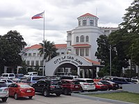 The San Juan Government Center along Pinaglabanan Street corner Doctor P. A. Narciso Street in Barangay Corazon de Jesus
 Santuario del Santo Cristo
 The old municipal hall of San Juan, with the San Juan Medical Center in the background.
 Virra Mall, one of many shopping areas in the Greenhills mixed-use development.
 The tiangge area of the Greenhills Shopping Center in Barangay Greenhills.
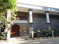 The Museo ng Katipunan located at Pinaglabanan Shrine.
 Commercial establishments along the city's main road, Nicanor Domingo Street.
 A panoramic view of San Juan from Xavier School Greenhills.
.jpg)
.jpg)


References
editExternal links
edit- Official website
- Philippine Standard Geographic Code
 Geographic data related to San Juan, Metro Manila at OpenStreetMap