Bestand:Two 1911-08-12 weather map.jpg
Geen hogere resolutie beschikbaar.
Two_1911-08-12_weather_map.jpg (417 × 305 pixels, bestandsgrootte: 24 kB, MIME-type: image/jpeg)
| Dit is een bestand van Wikimedia Commons. Onderstaande beschrijving komt van de beschrijving van het bestand daar. |
Beschrijving
| Beschrijving | ||||
| Datum | ||||
| Bron | NOAA Central Library Data Imaging Project | |||
| Auteur | NOAA Central Library, Silver Spring, Maryland | |||
| Toestemming (Hergebruik van dit bestand) |
|
Bestandsgeschiedenis
Klik op een datum/tijd om het bestand te zien zoals het destijds was.
| Datum/tijd | Miniatuur | Afmetingen | Gebruiker | Opmerking | |
|---|---|---|---|---|---|
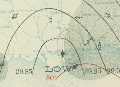
| huidige versie | 29 apr 2010 21:50 | | 417 × 305 (24 kB) | Juliancolton | {{Information |Description={{en|1=August 12, 1911 {{w|surface weather analysis}} of Hurricane Two in the {{w|1910 Atlantic hurricane season}} along the U.S. Gulf Coast. }} |Source=http://docs.lib.noaa.gov/rescue/dwm/1911/19110812.djvu |Author=[http://docs |
Bestandsgebruik
Dit bestand wordt op de volgende pagina gebruikt:
Globaal bestandsgebruik
De volgende andere wiki's gebruiken dit bestand:
- Gebruikt op ca.wikipedia.org
- Gebruikt op en.wikipedia.org
- Gebruikt op pt.wikipedia.org
- Gebruikt op zh.wikipedia.org
🔥 Top keywords: HoofdpaginaGeorgiëSpeciaal:ZoekenNico WilliamsLamine YamalJimmy Floyd HasselbainkMichael J. FoxFrank van den BroekEuropees kampioenschap voetbal mannenEuropees kampioenschap voetbal 2024Ibrahim AfellaySlowakijePhil FodenDick SchoofJan Mulder (voetballer, 1945)Mark RutteGareth SouthgateLisbeth ImboJude BellinghamRobin Le NormandGiorgi MamardasjviliEngels voetbalelftal (mannen)Willy SagnolKetikotiRonde van Frankrijk 2024Collin VeijerBruce SpringsteenGeorge Russell (autocoureur)Harry KaneChatGPTMarco PantaniBologna (stad)Jan BoellaardDani OlmoJordan BardellaJordan PickfordAthletic ClubMarc CucurellaEuropees kampioenschap voetbal 2020