Brown County, Kansas
Brown County (county code BR) is a county in the northeast part of the U.S. state of Kansas. In 2020, 9,508 people lived there.[1] Its county seat is Hiawatha. Hiawatha is the second-biggest city in Brown County.[2] Brown County is where the Kickapoo Indian Reservation of Kansas is. It also has most of the Sac and Fox Reservation and most of the Iowa Reservation of Kansas and Nebraska.
Brown County | |
|---|---|
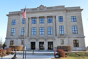
 Brown County Courthouse in Hiawatha (2011) | |
 Location within the U.S. state of Kansas | |
 Kansas's location within the U.S. | |
| Coordinates: 39°48′N 95°35′W / 39.800°N 95.583°W | |
| Country | |
| State | |
| Founded | August 25, 1855 |
| Named for | Albert Gallatin Brown |
| Seat | Hiawatha |
| Largest city | Hiawatha |
| Area | |
| • Total | 572 sq mi (1,480 km2) |
| • Land | 571 sq mi (1,480 km2) |
| • Water | 1.2 sq mi (3 km2) 0.2% |
| Population | |
| • Total | 9,508 |
| • Density | 16.7/sq mi (6.4/km2) |
| Time zone | UTC−6 (Central) |
| • Summer (DST) | UTC−5 (CDT) |
| Area code | 785 |
| Congressional district | 2nd |
| Website | brcoks.org |
History
changeBrown County was created in 1855.[3] It was named after Albert G. Brown.[4]
Geography
changeThe U.S. Census Bureau says the county has a total area of 572 square miles (1,480 km2). Of that, 571 square miles (1,480 km2) is land and 1.2 square miles (3.1 km2) (0.2%) is water.[5] The Wolf River has starts in the county.[6] Brown State Fishing Lake is in the county, 8 miles (13 km) east of Hiawatha.
Major highways
changePeople
change| Historical population | |||
|---|---|---|---|
| Census | Pop. | %± | |
| 1860 | 2,607 | — | |
| 1870 | 6,823 | 161.7% | |
| 1880 | 12,817 | 87.8% | |
| 1890 | 20,319 | 58.5% | |
| 1900 | 22,369 | 10.1% | |
| 1910 | 21,314 | −4.7% | |
| 1920 | 20,949 | −1.7% | |
| 1930 | 20,553 | −1.9% | |
| 1940 | 17,395 | −15.4% | |
| 1950 | 14,651 | −15.8% | |
| 1960 | 13,229 | −9.7% | |
| 1970 | 11,685 | −11.7% | |
| 1980 | 11,955 | 2.3% | |
| 1990 | 11,128 | −6.9% | |
| 2000 | 10,724 | −3.6% | |
| 2010 | 9,984 | −6.9% | |
| 2020 | 9,508 | −4.8% | |
| U.S. Decennial Census[9] 1790-1960[10] 1900-1990[11] 1990-2000[12] 2010-2020[1] | |||

Government
changePresidential elections
change| Year | Republican | Democratic | Third Parties |
|---|---|---|---|
| 2020 | 73.0% 3,262 | 24.7% 1,104 | 2.3% 105 |
| 2016 | 71.3% 2,906 | 21.2% 863 | 7.5% 304 |
| 2012 | 70.9% 2,829 | 27.0% 1,076 | 2.2% 88 |
| 2008 | 68.2% 2,985 | 30.1% 1,317 | 1.7% 74 |
| 2004 | 70.0% 3,092 | 28.7% 1,268 | 1.3% 58 |
| 2000 | 63.6% 2,985 | 32.2% 1,512 | 4.1% 194 |
| 1996 | 56.6% 2,688 | 32.2% 1,529 | 11.2% 534 |
| 1992 | 41.6% 2,203 | 27.9% 1,476 | 30.5% 1,615 |
| 1988 | 63.6% 3,059 | 35.7% 1,719 | 0.7% 34 |
| 1984 | 74.0% 3,894 | 24.8% 1,303 | 1.3% 67 |
| 1980 | 67.6% 3,598 | 25.7% 1,370 | 6.7% 354 |
| 1976 | 65.0% 3,407 | 33.3% 1,745 | 1.8% 93 |
| 1972 | 78.9% 4,314 | 19.0% 1,038 | 2.1% 114 |
| 1968 | 69.2% 3,748 | 22.1% 1,199 | 8.7% 473 |
| 1964 | 57.0% 3,213 | 42.3% 2,386 | 0.7% 37 |
| 1960 | 72.3% 4,707 | 27.2% 1,773 | 0.5% 35 |
| 1956 | 77.0% 5,138 | 22.8% 1,519 | 0.3% 20 |
| 1952 | 80.5% 6,031 | 19.2% 1,440 | 0.3% 20 |
| 1948 | 68.0% 4,518 | 31.0% 2,060 | 1.0% 68 |
| 1944 | 73.0% 4,947 | 26.8% 1,817 | 0.2% 15 |
| 1940 | 69.2% 6,008 | 30.3% 2,633 | 0.5% 43 |
| 1936 | 62.4% 5,814 | 37.5% 3,495 | 0.1% 11 |
| 1932 | 57.7% 5,005 | 41.6% 3,604 | 0.7% 60 |
| 1928 | 76.8% 6,692 | 23.0% 2,005 | 0.2% 20 |
| 1924 | 68.9% 5,647 | 22.8% 1,866 | 8.3% 678 |
| 1920 | 72.3% 5,249 | 26.7% 1,937 | 1.1% 76 |
| 1916 | 52.9% 4,282 | 43.3% 3,503 | 3.9% 315 |
| 1912 | 31.2% 1,512 | 36.7% 1,774 | 32.1% 1,554 |
| 1908 | 56.3% 2,778 | 41.4% 2,044 | 2.3% 111 |
| 1904 | 68.6% 3,158 | 27.0% 1,244 | 4.3% 200 |
| 1900 | 57.1% 3,137 | 41.8% 2,298 | 1.1% 59 |
| 1896 | 51.7% 2,879 | 47.0% 2,618 | 1.4% 77 |
| 1892 | 52.0% 2,562 | 47.9% 2,362 | |
| 1888 | 55.6% 2,696 | 37.2% 1,803 | 7.3% 352 |
Brown County very Republican. Brown was Alf Landon’s strongest county in his home state during his 1936 presidential campaign. Noo Democratic presidential candidate has ever won a most of the votes Brown County.
Education
changeUnified school districts
changeCommunities
change
Cities
changeReferences
changeMore reading
change- Standard Atlas of Brown County, Kansas; Geo. A. Ogle & Co; 70 pages; 1919.
- Plat Book of Brown County, Kansas; Northwest Publishing Company; 44 pages; 1904.
- Meacham's Illustrated Atlas of Brown and Nemaha Counties, Kansas; J.H. Meacham & Company; 127 pages; 1887.
Other websites
change
- County
- Maps