Puy-de-Dôme
Puy-de-Dôme is a French department in the centre of France in the Auvergne-Rhône-Alpes region and named after the dormant volcano the Puy de Dôme. Its prefecture is the city of Clermont-Ferrand.
Puy-de-Dôme | |
|---|---|
 Prefecture building of the Puy-de-Dôme department, in Clermont-Ferrand. | |
 Flag  Coat of arms | |
 Location of Puy-de-Dôme in France | |
| Coordinates: 45°42′N 3°13′E / 45.700°N 3.217°E | |
| Country | France |
| Region | Auvergne-Rhône-Alpes |
| Département | 4 March 1790 |
| Prefecture | Clermont-Ferrand |
| Subprefectures | Ambert, Issoire, Riom, Thiers |
| Government | |
| • President | Jean-Yves Gouttebe |
| Area | |
| • Total | 7,969.7 km2 (3,077.1 sq mi) |
| Population (2014)[3] | |
| • Total | 644,216 |
| • Density | 81/km2 (210/sq mi) |
| Demonym | Puydômois |
| Time zone | UTC+1 (CET) |
| • Summer (DST) | UTC+2 (CEST) |
| ISO 3166 code | FR-63 |
| Arrondissements | 5 |
| Cantons | 31 |
| Communes | 467 |
| Website | http://www.puy-de-dome.fr/ |
History
changePuy-de-Dôme was created in 1790 during the French Revolution, when the whole of France was divided into departments, replacing the old provinces. Puy-de-Dôme was formed with part of the old province of Auvergne.
It was divided in eight districts: Ambert, Besse, Billom, Clermont-Ferrand, Issoire, Montaigu, Riom and Thiers, with Clermont-Ferrand as is capital.[4]
In 1800, with the creation of the arrondissements in France, the eight districts were changed into five arrondissements: Ambert, Clermont-Ferrand, Issoire, Riom and Thiers. On 10 September 1926, the arrondissement of Ambert was eliminated but, in 1942 Ambert became again an arrondissement of the department.[4]
Geography
changePuy-de-Dôme is part of the Auvergne-Rhône-Alpes region, in east-central France, with an area of 7,969.7 km2 (3,077 sq mi).[2]
The department borders with 2 other departments in 2 regions:
- Nouvelle-Aquitaine region
- Auvergne-Rhône-Alpes region
- Allier (north)
- Loire (east)
- Haute-Loire (southeast)
- Cantal (southwest)
The department is in the Massif Central and there are several mountain chains; some of the chains and mountains are:
- Chaîne des Puys, to the northwest of the department; here is the Puy de Dôme, a dormant volcano.
- Monts Dore, to the southwest of the department. Here is the highest mountain of the department and of the Massif Central: Puy de Sancy, an extinct volcano (45°31′42″N 02°48′50″E / 45.52833°N 2.81389°E); it is 1,885 m (6,184 ft) high.[5]
- Monts du Forez, to the east of the department
- Livradois, to the south.
- Massif des Bois Noirs, to the northeast.
- Cézallier, to the southwest.
Climate
changeThe climate of the Puy-de-Dôme department, in the city of Clermont-Ferrand, is an oceanic climate, Cfb (Marine West Coast Climate) in the Köppen climate classification.
The average temperature for the year in Clermont-Ferrand, at an altitude of 330 m (1,080 ft), is 10 °C (50 °F). The warmest month, on average, is July with an average temperature of 18.9 °C (66.0 °F). The coolest month on average is January, with an average temperature of 0.6 °C (33.1 °F).
The average amount of precipitation for the year in Clermont-Ferrand is 612.1 mm (24.1 in). The month with the most precipitation on average is May with 73.7 mm (2.9 in) of precipitation. The month with the least precipitation on average is January with an average of 30.5 mm (1.2 in).[6]
Administration
changePuy-de-Dôme is part of the region of Auvergne-Rhône-Alpes. The department is managed by the Departamental Council of the Puy-de-Dôme in Clermont-Ferrand.
Administrative divisions
changeThere are 5 arrondissements (districts), 31 cantons and 467 communes (municipalities) in Puy-de-Dôme.[7]
| INSEE code | Arrondissement | Capital | Population[8] (2014) | Area[9] (km²) | Density (Inh./km²) | Communes |
|---|---|---|---|---|---|---|
| 631 | Ambert | Ambert | 26,653 | 1,188.1 | 22.4 | 58 |
| 632 | Clermont-Ferrand | Clermont-Ferrand | 375,518 | 1,796.5 | 209.0 | 75 |
| 633 | Issoire | Issoire | 62,931 | 1,819.6 | 34.6 | 135 |
| 634 | Riom | Riom | 121,158 | 2,299.7 | 52.7 | 155 |
| 635 | Thiers | Thiers | 57,956 | 865.8 | 66.9 | 44 |
The following is a list of the 31 cantons of the Puy-de-Dôme department (with their INSEE codes), in France, following the French canton reorganisation which came into effect in March 2015:[10]
- Aigueperse (6301)
- Ambert (6302)
- Aubière (6303)
- Beaumont (6304)
- Billom (6305)
- Brassac-les-Mines (6306)
- Cébazat (6307)
- Chamalières (6308)
- Châtel-Guyon (6309)
- Clermont-Ferrand-1 (6310)
- Clermont-Ferrand-2 (6311)
- Clermont-Ferrand-3 (6312)
- Clermont-Ferrand-4 (6313)
- Clermont-Ferrand-5 (6314)
- Clermont-Ferrand-6 (6315)
- Cournon-d'Auvergne (6316)
- Gerzat (6317)
- Issoire (6318)
- Lezoux (6319)
- Maringues (6320)
- Les Martres-de-Veyre (6321)
- Les Monts du Livradois (6322)
- Orcines (6323)
- Pont-du-Château (6324)
- Riom (6325)
- Saint-Éloy-les-Mines (6326)
- Saint-Georges-de-Mons (6327)
- Saint-Ours (6328)
- Le Sancy (6329)
- Thiers (6330)
- Vic-le-Comte (6331)
Demographics
changeThe inhabitants of Puy-de-Dôme are known, in French, as Puydômois (women: Puydômoises).[11]
Puy-de-Dôme has a population, in 2014, of 644,216,[3] for a population density of 80.8 inhabitants/km2. The arrondissement of Clermont-Ferrand, with 375,518 inhabitants, is by far the largest.[8]
Evolution of the population in Puy-de-Dôme

The most important cities in the department are:
| City | Population[8] (2014) | Arrondissement |
|---|---|---|
| Clermont-Ferrand | 141,365 | Clermont-Ferrand |
| Cournon-d'Auvergne | 19,515 | Clermont-Ferrand |
| Riom | 18,749 | Riom |
| Chamalières | 17,623 | Clermont-Ferrand |
| Issoire | 14,578 | Issoire |
| Thiers | 11,588 | Thiers |
| Beaumont | 11,060 | Clermont-Ferrand |
| Pont-du-Château | 10,655 | Clermont-Ferrand |
| Gerzat | 10,487 | Clermont-Ferrand |
| Aubière | 9,832 | Clermont-Ferrand |
Gallery
change Departmental Council building.
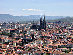 The black Clermont-Ferrand Cathedral.
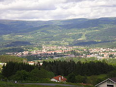
 Place de la Republique, Issoire.
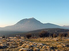 The Puy de Dôme volcano.


Related pages
changeReferences
change- ↑ "Bureau départemental" (in French). Conseil départemental du Puy-de-Dôme (63). Retrieved 16 October 2017.
- ↑ 2.0 2.1 "Département du Puy-de-Dôme (63)". Comparateur de territoire (in French). Institut national de la statistique et des études économiques - INSEE. Retrieved 16 October 2017.
- ↑ 3.0 3.1 "Populations légales 2014 des départements et des collectivités d'outre-mer" (in French). Institut national de la statistique et des études économiques - INSEE. Retrieved 16 October 2017.
- ↑ 4.0 4.1 "Historique du Puy-de-Dôme". Le SPLAF (in French). Retrieved 17 October 2017.
- ↑ "Puy de Sancy, France". Peakbagger.com. Retrieved 17 October 2017.
- ↑ "Clermont-Ferrand, France - Köppen Climate Classification". Weatherbase. Retrieved 17 October 2017.
- ↑ "Département du Puy-de-Dôme (63)" (in French). Institut national de la statistique et des études économiques - INSEE. Retrieved 17 October 2017.
- ↑ 8.0 8.1 8.2 "Régions, départements, arrondissements, cantons et communes" (PDF). Populations légales 2014 (in French). Institut national de la statistique et des études économiques - INSEE. Retrieved 17 October 2017.
- ↑ "Département du Puy-de-Dôme (63)". Comparateur de territoire (in French). Institut national de la statistique et des études économiques - INSEE. Retrieved 17 October 2017.
- ↑ "Décret n° 2014-210 du 21 février 2014 portant délimitation des cantons dans le département du Puy-de-Dôme" (in French). Légifrance.gouv.fr. 26 February 2014. Retrieved 17 October 2017.
- ↑ "Puy-de-Dôme" (in French). habitants.fr. Retrieved 17 October 2017.
Other websites
change- Departamental Council website (in French)
- Prefecture website (in French)