Fil:Zhou occidentaux etats.svg

Storleken för denna PNG-förhandsvisning av denna SVG-fil: 568 × 384 pixlar. Andra upplösningar: 320 × 216 pixlar | 640 × 433 pixlar | 1 024 × 692 pixlar | 1 280 × 865 pixlar | 2 560 × 1 731 pixlar.
Originalfil (SVG-fil, standardstorlek: 568 × 384 pixlar, filstorlek: 712 kbyte)
| Denna fil tillhandahålls av Wikimedia Commons. Informationen nedan är kopierad från dess filbeskrivningssida. |
Sammanfattning
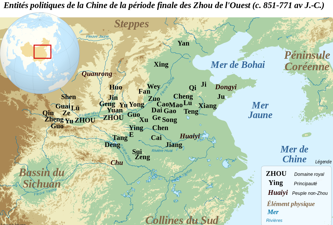
| Beskrivning | Français : Carte de localisation des principales entités politiques de la Chine du Nord durant la période finale des Zhou de l'Ouest (c. 851-771 av. J.-C. Les localisations des principautés sont souvent approximatives, et reposent sur les propositions et cartes de F. Li, Landscape and Power in Early China, The Crisis and Fall of the Western Zhou 1045-771 BC, New York, 2006. Les principautés de l'Ouest (Zheng, Guo, Shen, Lü et Qin) sont localisées avant leurs migrations vers l'est. English: Location map of the main political actors of the Late Western Zhou Period (c. 851-771 BC). Many of the locations given are only approximate, and based on the conclusions and maps of F. Li, Landscape and Power in Early China, The Crisis and Fall of the Western Zhou 1045-771 BC, New York, 2006. Western states such as Zheng, Guo, Shen, Lü and Qin are located before their eastward migrations. |
| Datum | |
| Källa | Denna fil bygger på: Chinese plain 5c. BC-fr.svg: |
| Skapare |
|
| Detta är en retuscherad eller på annat sätt behandlad bild, med vilket menas att den har redigerats digitalt från sitt original. Redigeringar: suppression frontières, ajout des états. Originalet kan ses här: Chinese plain 5c. BC-fr.svg. Redigeringar gjorda av Zunkir. |
Licensiering
Jag, upphovsrättsinnehavaren av detta verk, publicerar härmed det under följande licens:
Denna fil har gjorts tillgänglig under licensen Creative Commons Erkännande-Dela Lika 3.0 Unported
- Du är fri:
- att dela – att kopiera, distribuera och sända verket
- att remixa – att skapa bearbetningar
- På följande villkor:
- erkännande – Du måste ge lämpligt erkännande, ange en länk till licensen och indikera om ändringar har gjorts. Du får göra det på ett lämpligt sätt, men inte på ett sätt som antyder att licensgivaren stödjer dig eller din användning.
- dela lika – Om du remixar, transformerar eller bygger vidare på materialet måste du distribuera dina bidrag under samma eller en kompatibel licens som originalet.
Ursprunglig uppladdningslogg
This image is a derivative work of the following images:
- File:Chinese_plain_5c._BC-fr.svg licensed with Cc-by-sa-3.0
Uploaded with derivativeFX
Filhistorik
Klicka på ett datum/klockslag för att se filen som den såg ut då.
| Datum/Tid | Miniatyrbild | Dimensioner | Användare | Kommentar | |
|---|---|---|---|---|---|
| nuvarande | 6 augusti 2012 kl. 17.52 | | 568 × 384 (712 kbyte) | Zunkir | Nouvel essai. |
| 6 augusti 2012 kl. 17.50 |  | 568 × 384 (712 kbyte) | Zunkir | Reverted to version as of 15:46, 6 August 2012 | |
| 6 augusti 2012 kl. 17.49 |  | 568 × 384 (712 kbyte) | Zunkir | Reverted to version as of 09:20, 6 August 2012 | |
| 6 augusti 2012 kl. 17.46 |  | 568 × 384 (712 kbyte) | Zunkir | Nouvel essai. | |
| 6 augusti 2012 kl. 11.20 |  | 568 × 384 (712 kbyte) | Zunkir | Modif localisation des Quanrong. | |
| 30 april 2012 kl. 11.56 |  | 568 × 384 (712 kbyte) | Zunkir | == {{int:filedesc}} == {{Information |Description={{fr|1=Carte de localisation des principales entités politiques de la Chine du Nord durant la période finale des Zhou de l'Ouest (c. 851-771 av. J.-C. Les localisations des principautés sont souvent ... |
Filanvändning
Följande sida använder den här filen:
Global filanvändning
Följande andra wikier använder denna fil:
- Användande på en.wikipedia.org
- Användande på fr.wikipedia.org
- Användande på it.wikipedia.org
- Användande på ja.wikipedia.org
- Användande på pl.wikipedia.org
- Användande på ru.wikipedia.org
🔥 Top keywords: